It’s a little over a year since we moved to the Overberg region of the Western Cape. To celebrate this anniversary, here is a random round-up of some the photographs taken when we were out and about during the course of the year.
The Overberg (‘berg’ means mountain or mountain range) is so-named because it is literally ‘over the mountains’ from the Cape Town side. The Hottentot Holland mountains rise up from the lowlands or flats to the east of Cape Town and, stretching from the coast and inland towards Franschhoek, they form a high barrier to the Overberg.

Map showing the Overberg District Municipality – from Google Maps https://www.google.com/maps/place/Overberg_District_Municipality/
The Hottentots Holland mountains start at Rooi Els (indicated on the above map) on the coast and range inland in a north-easterly direction past Grabouw and beyond towards Franschoek. Sir Lowry’s Pass, on the N2 national road between Cape Town and Grabouw, provides access over the mountains.
The Atlantic Ocean is to the west and the Indian Ocean to the east. The southernmost point of Africa at Cape Agulhas (just south west of Struisbaai on the map) marks the official dividing line between the two oceans.

This photo is taken from Clarence Drive on the Cape Town (western) side of the Hottentots Holland mountains. The view across a section of False Bay is towards the mountains that form a dramatic barrier to the Overberg on the other side. Klein Hangklip mountain, at the southern end of the Hottentots Mountains at Rooi Els (near Pringle Bay), can be seen in the distance at the extreme right

The Overberg has a long coastline so photos of the sea, such as this one with kelp visible in the foreground, are inevitable
The Western Cape coast is well known for being a whale-watching destination, with a section of the Overberg coastline centred on Hermanus dubbed the Cape Whale Coast. Good viewings from cliffs or high dunes offer excellent land-based opportunities to watch southern right whales (Eubalaena australis) that visit the bays along the coast between June and late November. Some arrive to mate in the sheltered bays, and pregnant females arrive to calve and raise their young in warmer waters before migrating back to cooler southern waters where they feed on krill. Also along the Cape coast are humpback (Megaptera novaeangliae)and Bryde (Balaenoptera brydei) whales, which are less commonly seen from the Overberg shores.

Whales are not easy to photograph. Unusually, this southern right whale (photographed from De Kelders near Gansbaai) showed itself above the water from head to tail. Some callosities are just visible on its head. Typically, adults are in the region of 15 m (49 ft) in length. Southern right whales do not have a dorsal fin

From a popular vantage point on the cliffs at Sievers Point at Hermanus, using my cell phone I snapped this photo of a nearby southern right whale repeatedly tail slapping while it was close-by at high tide. There were many whales in the bay that day, with several engaged in tail slapping (known as lobtailing) while other whales we saw breaching on the far side of the bay
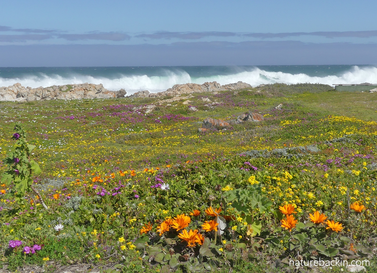
A surprising diversity of plants grow right down to the rocks on the sea shore. Many coastal plants are spectacular when in flower (the header photo was taken close to Danger Point near Gansbaai in September last year), and year-round the coastal vegetation provides food and shelter for birds and animals.

A rock hyrax (Procavia capensis), known locally as a dassie, watching us somewhat warily from the safety of coastal vegetation. Dassies, predominantly herbivores, occur throughout sub-Saharan African and the Middle East in a variety of habitats

Looking out over coastal vegetation across a small bay to the promontory named Danger Point. The name is due to the offshore rocks and reefs that are dangerous to ships travelling near to the coast where there have been many shipwrecks. The Danger Point Lighthouse is visible on the horizon

The road to the Danger Point lighthouse passes through thick coastal fynbos vegetation. The Danger Point lighthouse has been operating since it was built in 1895, following the sinking of the troop carrier HMS Birkenhead in 1852 after it struck an uncharted rock. Of the estimated 643 people on board the Birkenhead only 193 survived

Flowering at the edge of the bay near Danger Point, we saw these cheerful daisies, which I think are likely to be the hardy coastal groundcover species Dimorphotheca fruticosa. Their semi-succulent leaves enable them to survive salty sea spray and gale-force winds

A pair of African oystercatchers (Haematopus moquini) – also known as African black oystercatchers – foraging on rocks between Danger Point and Kleinbaai. These oystercatchers are endemic to the southern African coast, with breeding sites on the off-shore islands and along the Namibian and Western Cape coasts and eastwards to Mazeppa Bay in the Eastern Cape. Non-breeding birds occur on Kwa-Zulu Natal and Angolan coasts. For more about these birds see here

Hartlaub’s gulls (Chroicocephalus hartlaubii) resting in a sheltered spot and enjoying some midday sunshine, also near Danger Point. For more on Overberg gulls see here

We saw this blacksmith lapwing (Vanellus armatu) – also known as blacksmith plover – foraging in coastal vegetation alongside the sandy-rocky strip where the gulls were resting. Blacksmith lapwings also occur inland across the country where they are mostly associated with inland water systems, both natural and artificial. They breed close to water, for example on mudflats, and forage on moist short grassy area such as around dams, and in opens spaces like sports fields and heavily-grazed lands. Their name derives from their call that sounds a bit like a blacksmith striking an anvil. Recordings of the call may be heard here

I snapped this photo of three kelp gulls (Larus dominicanus) at Walker Bay, which is 20 minutes’ drive along a mostly dirt road from Stanford

And moving away from the coast, this pretty valley is inland from Gansbaai – not far from the small village of Baardskeedersbos

Canola fields in flower – photographed through the window of our car while travelling near Swellendam. The Overberg is considered to be the breadbasket of the Cape, and wheat, barley and oats are grown in the region. The fruit orchards in the Elgin area produce predominantly apples and pears. The Overberg vineyards and wine route are attracting increasing attention. Livestock farming also forms part of the diversity of farming activities in the region

Two grey herons (Ardea cinerea) perching on a nest situated in the reeds at the Vermont Salt Pan. Two other herons were also coming and going from the nest site. Grey herons have a wide distribution in two hemispheres and occur on the Iberian Peninsula, in the United Kingdom and parts of Scandinavia. They also occur in Asia, including in China and Japan and in India. On the African continent they occur in the north-western region and over much of sub-Saharan Africa and on the island of Madagascar. In southern Africa they are pretty much resident rather than migratory
The Vermont pan is located slightly inland and is not directly on the coast. Although known as the Vermont Salt Pan, it is really a mildly saline wetland with the amount of water in the pan varying across the seasons. The wetland system attracts many birds seasonally even though it is in the residential suburb of Vermont, which is on the western side of Hermanus. Vermont dedicates 20% of its area to conserving local vegetation in greenbelt areas or corridors that protect endangered fynbos. The Vermont Salt Pan falls in one such corridor.

A breeding platform for cormorants is situated in the middle of the pan, where we saw several white breasted cormorants (Phalacrocorax lucidus) nesting. Perched on a rock on the edge of the pan, we saw this smaller cormorant, which is either a reed cormorant (Microcarbo africanus) or a crowned cormorant (Microcarbo coronatus). Apparently both species have been seen at the pan.

This vista with the Klein River below and fynbos in the foreground, is from the slopes of the Klein River Mountains at the Phillipskop Mountain Reserve, which is about 10 km (6 miles) east of Stanford

And providing a small taste of the fynbos, most strikingly in flower when we went on a short hike in the Phillipskop Mountain Reserve during December, were numerous red everlasting (Phaenocoma prolifera) plants. This species is the only member of its genus. The leaves are small and knob-like, almost as if they are tightly furled

Rock formations in the Klein River mountains at Phillipskop Mountain Reserve
This small selection of photographs is not exactly an Overberg overview, but perhaps provides some idea of land- and sea-scapes in the region.

And leaving the Overberg towards Cape Town – approaching the top of Sir Lowrie’s Pass on the N2 before descending into Somerset West at the foot of the pass
Posted by Carol


May 5, 2024 at 7:58 am
I so enjoyed this blog, Carol, you captured so much of the essence of the Overberg but it is also so unique being seen through your eyes! Wonderful photographs!
LikeLiked by 1 person
May 13, 2024 at 6:53 pm
Thanks so much Christine. I enjoying going through the photos taken over the year.
LikeLike
April 28, 2024 at 6:34 pm
Looks like a magnificent place to live, Carol! Thank you for sharing all these beautiful views.
LikeLiked by 1 person
April 30, 2024 at 6:57 pm
Thanks Carol – it was interesting selecting some photos to share. There are many beautiful mountains, beaches and landscapes in this region.
LikeLiked by 1 person
April 30, 2024 at 6:59 pm
I hope the flooding has not affected you to adversely and hope you will continue to enjoy your spectacular new home!
LikeLiked by 1 person
April 30, 2024 at 7:08 pm
Thanks so much Carol. We are ok after the flooding as our house is relatively high up, but some of the people whose houses were flooded had their lives turned upside down, and some are still not able to move back in. Being close to that flood has made me a little more aware when I read about flooding and other disasters the world over in the news.
LikeLiked by 1 person
April 30, 2024 at 7:10 pm
Definitely!
We too are in a precarious zone here in Florida because of hurricanes, but have thankfully never yet been directly affected by major one.
LikeLiked by 1 person
April 30, 2024 at 8:08 pm
And I hope that continues to be the case where you are. We had more heavy rain in few days recently, but fortunately though the river rose it did not flood. So many places seem to be precariously situated these days …
LikeLiked by 1 person
April 27, 2024 at 8:40 am
I could almost smell the sea and the West Coast fynbos as I looked at these stunning photographs. Thank you for the tour.
LikeLike
April 27, 2024 at 11:38 am
Thanks Mariss. The smell of the fynbos (and of the ocean) is a wonderful added dimension.
LikeLiked by 1 person
April 26, 2024 at 1:21 pm
I thoroughly enjoyed your overview of the Overberg, Carol. Your photos and descriptions are marvelous, and I am impressed with all you have seen in just a year on top of moving into a new place. I loved seeing how huge the southern right whale was, beautiful kelp scenes, the whale tail, the rock hyrax and kelp gulls, lapwing and seaside plants. Once while in Africa a hyrax screamed the most hair-raising call at us! Good luck in the months ahead with all the move entails, and thanks for taking the time to give us this portrait of the Overberg.
LikeLiked by 1 person
April 27, 2024 at 11:36 am
Hi Jet, thanks for your best wishes and kind words. Moving involves a lot more than one might expect. I imagine you found that too?
What an experience to hear the scream of the hyrax! Astonishing as well as hair raising. (I have only heard recordings.)
LikeLiked by 1 person
April 25, 2024 at 10:11 am
Such a beautiful region, Carol. Thank you for the opportunity to see and learn more about it.
LikeLiked by 1 person
April 25, 2024 at 12:58 pm
Hi Sandra – thanks for visiting. Yes it is very beautiful here. As we get more settled hopefully we will have more time to explore.
LikeLiked by 1 person
April 25, 2024 at 9:52 am
No wonder you’ve been posting less frequently. So much wonderful new territory to discover. I hope you’re happily settled by now.
LikeLiked by 1 person
April 25, 2024 at 12:56 pm
Hi Margaret – lots to explore and we need to do more of it. Incredibly, we are still very busy with DIY renovations at home. Only recently have we had time to start to be a little creative in the garden. For one thing it is very hard to adjust to almost no rain in the summer (Mediterranean climate). Settling in seems to be an ongoing process, but it is happening 😊🌱
LikeLike
April 25, 2024 at 7:46 am
Such beautiful flora and fauna! Your photographs are so so amazing!
LikeLiked by 1 person
April 25, 2024 at 12:51 pm
Thanks so much for visiting and for your kind comment Ajanta.
LikeLiked by 1 person
April 25, 2024 at 2:40 pm
You are very welcome and thank you for sharing the exquisite views!
LikeLiked by 1 person
April 25, 2024 at 4:16 am
Beautiful landscape! I would like to note that I have also seen Haematopus moquini in southern New Zealand.
LikeLiked by 1 person
April 25, 2024 at 12:28 pm
Thanks Simone – it is beautiful here. I was interested to read that you have seen the African oystercatcher (Heamatopus moquini) in southern New Zealand, but I can find no reference to it occurring anywhere other than southern Africa. However, endemic to New Zealand is the variable oyster catcher (Haematopus unicolour) that is polymorphic, and includes a pied morph (with white underparts) and an all-black morph that closely resembles the African oystercatcher, so I am wondering if that is what you saw, perhaps?
I also learned that there is a second endemic oystercatcher in NZ – the South Island pied oystercatcher (Haematopus finschi).
LikeLiked by 1 person
April 26, 2024 at 4:24 pm
Dear Carol, I have now done some more research and have come to the conclusion that perhaps the german Wikipedia is wrong.
I probably saw some of Haematopus unicolour in New Zealand. I read: “the proportion of pure black birds increases the further south you go.”
I sighted the all-black birds in the south of the South Island (Curio Bay).
I also read that the adults of the African oystercatcher are very localised. If so, then it could only have been juveniles in New Zealand.
There was also a Canarian oystercatcher. Also black and extinct.
The categorisation of oystercatchers seems to be controversial. Learned something new again. 😊
LikeLiked by 1 person
April 25, 2024 at 1:54 am
Thank you for sharing some beautiful scenes of your new home, and of some of the no less beautiful denizens. Your header photo with the various colors, waves, and blue sky took my breath away.
LikeLiked by 1 person
April 25, 2024 at 12:13 pm
Thanks Tanja – I hope to be showing more of the birds and animals going forward. I am also fond of that header photo. The flowers are mind blowing, and even more so being close to the sea.
LikeLiked by 1 person
April 26, 2024 at 2:43 am
I look forward to seeing more of your birds and animals, Carol. Somehow I missed your previous posts and could no longer leave a comment, but I wanted to let you know that your photos of the angulate tortoise eating dandelions were utterly enchanting!
LikeLiked by 1 person
April 27, 2024 at 11:28 am
I am very happy to hear that you enjoyed the very charming and enchanting tortoise 🐢🙂
(Btw, I have started putting a time limit on comments to cut down on spam, and it has made an enormous difference in that respect.)
LikeLiked by 1 person
April 28, 2024 at 6:57 pm
Yes, your tortoise photos left an indelible impression on my mind and I smile just thinking about them. 🙂
Sorry to hear about your spam problem, that’s frustrating.
LikeLiked by 1 person
April 30, 2024 at 7:03 pm
Indeed, there is something very cheering about the tortoise eating the dandelions.
LikeLiked by 1 person
April 25, 2024 at 12:15 am
Such beautiful countryside shots, Carol. You’ve moved to paradise! 🙂
LikeLiked by 1 person
April 25, 2024 at 12:10 pm
Hi Eliza -we are very lucky to be here – though as anywhere, there are lots of not so beautiful places that I have ignored …
LikeLiked by 1 person
April 24, 2024 at 8:07 pm
Absolutely gorgeous!
LikeLike
April 25, 2024 at 12:08 pm
Thanks very much M.B. – there is lots of beauty around here.
LikeLiked by 1 person
April 24, 2024 at 5:17 pm
Lovely tour of your new home area. I hope you’ve settled in and are enjoying living there. Looks like you have a good variety of landscape and nature to explore. I was interested to see that’s where HMS Birkenhead sank, an incident well known in the ethos of evacuating ‘women and children first.’
LikeLike
April 24, 2024 at 7:00 pm
Hi Graham – I am learning that settling it takes time, but I am feeling more at ease here now as things become more familiar. It is a beautiful region with lots to explore and appreciate.
The sad and dramatic Birkenhead story is well commemorated here. In fact many of the survivors were brought here to Stanford for temporary shelter after their ordeal.
LikeLiked by 1 person
April 25, 2024 at 5:47 am
Well, I look forward to reading about your explorations!
LikeLiked by 1 person
April 24, 2024 at 1:37 pm
What glorious land- and seascapes you have brought to our screens, Carol. Such beautiful photography.
LikeLike
April 24, 2024 at 6:57 pm
Thanks very much Tish. This certainly is a most photogenic part of the world!
LikeLiked by 1 person
April 24, 2024 at 12:26 pm
Thanks for ther ‘Gnus’ . I must get in to the habit of taking more photos. One gets lazy with all the technical cellphones we have. I have an interesting plant in the garden⦠Dracanea.
John
LikeLike
April 24, 2024 at 6:55 pm
Hi John – certainly one can get overwhelmed by taking too many photos using one’s phone, so perhaps not taking a lot is quite a good thing! The only Dracaena I know that comes to mind is ‘mother-in-law’s tongue’. Sending best wishes.
LikeLike
April 24, 2024 at 11:54 am
You have chosen a beautiful place to live in after KZN. These pictures are lovely. I especially like white daisies and the everlastings. What a lot of rich discoveries await you!
LikeLike
April 24, 2024 at 6:49 pm
Hi Anne – Thank you, and yes there is a lot that is beautiful around here. The flowers can be entrancing. Indeed, many discoveries await. I am learning bits and pieces little by little. I miss “home” but I am starting to feel more at ease here.
LikeLike
April 25, 2024 at 7:44 am
That is good to know. When we arrived in Grahamstown I felt I had landed on an alien planet until I got to know some of the trees, flowers and birds here.
LikeLiked by 1 person
April 27, 2024 at 11:25 am
Yes, it does feel very alien! I started by noticing plants and flowers that occur both here and in KZN and have been learning from there
The summers without even the prospect of much rain are very hard to get used to. Out in the country the golden landscapes look like winter to me!
LikeLiked by 1 person
April 24, 2024 at 11:44 am
Love the photo of kelp gulls. Must be fun learning all the new flora and fauna.
LikeLike
April 24, 2024 at 6:45 pm
Hi Nikki – How nice to hear from you. I like that photo too. I was pleased to get all three in the frame! Yes there is lots to learn – I am enjoying it, although sometimes it can be quite difficult to find out what I’d like to know!
Luckily I found that your comment had been spammed for some reason! Disconcerting when that happens.
LikeLike