We are back from our trip to the Western Cape, travelling a distance of about 4000 km (2484 miles). Perhaps sharing photos taken from the car while travelling is a useful way of conveying something of the feel of the journey?
This selection of photos is not really representative – for one thing I do not take photos when it is my turn to drive (in case you might be wondering), and sometimes the light produces too much glare to make taking photos feasible. Most of these photos were taken through the windscreen or side window while travelling, so technically brilliant they ain’t, but perhaps they give a randomish overview of some of what we saw.
We drove from Pietermaritzburg in KwaZulu-Natal to our ultimate destination, Onrus, a seaside settlement adjacent to Hermanus in the Western Cape. We passed through parts of the Free State and Eastern Cape provinces on both legs of the journey, avoiding retracing our route on the return journey as much as possible. To give some idea of where we went I add a rather sketchy map of our route at the end of this post.

Driving through farming areas, we often saw small dust-devils whirling across barren land
Dryness was a constant presence, especially in the Free State and the Eastern Cape. The farmlands were desiccated and dusty with little evidence of spring rains even in the summer rainfall areas. In the few better-off areas where there was still surface water cattle looked to be in reasonable condition, but irrigation systems appeared to be standing idle.
In many places along the roadside, farm homesteads and outbuildings looked rundown. Some were seemingly abandoned, and others looked to be hanging on despite little productivity being evident and what livestock there was looking thin.

Driving by it was hard to tell if this farm was still in any way active or even inhabited
In South Africa travelling any great distance even on minor roads entails travelling on long almost endless stretches of dead straight roads through flat countryside where telephone poles provide the tallest landmarks. Birds make use of these poles as perches and for nesting. We frequently saw crows’ nests atop telephone poles, often with a parent bird sitting in the nest in blazing heat, resolutely protecting eggs or fledglings.
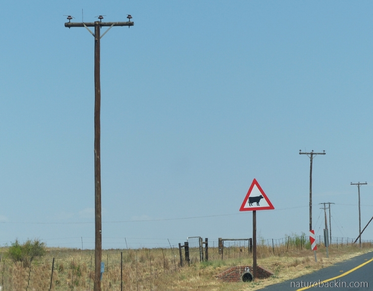
Two anachronisms in this photo: the telephone poles clearly show that communication systems are going wireless and not many cattle were in evidence, either in the fields or crossing the roads
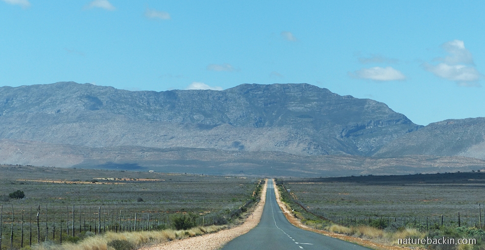
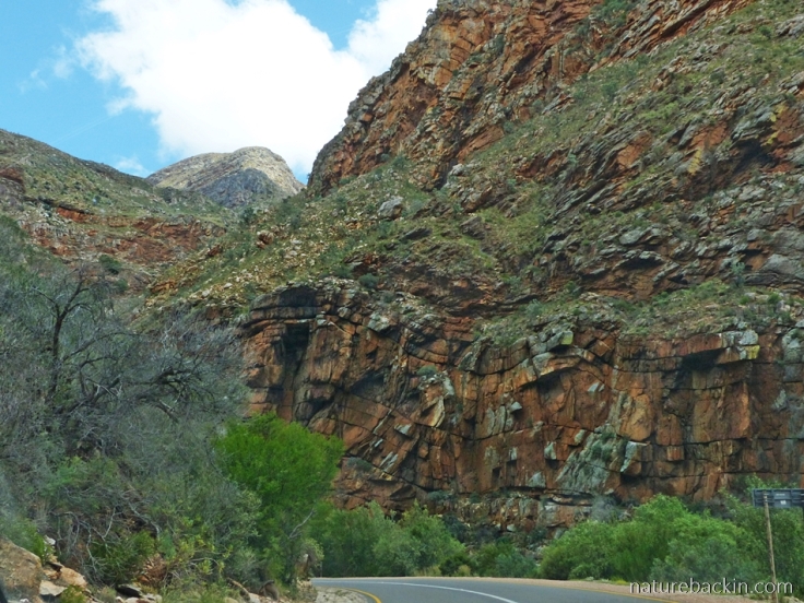
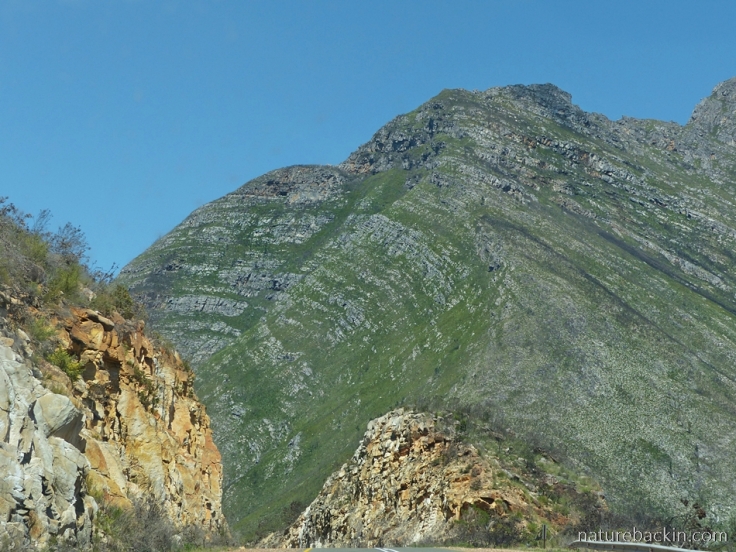
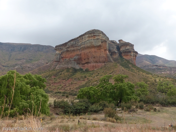
Near Beaufort West, the road we took drops down from the inland plateau into the Karoo Basin. From there we took the route that runs almost due south as it approaches the Swartberg range of mountains, one of the Cape Fold range of mountains that runs from west to east parallel with other ranges that run almost parallel with the coast. As can be seen in the header image, the road runs towards a wall of high mountains that seemingly block access with no through route ultimately to the coast.
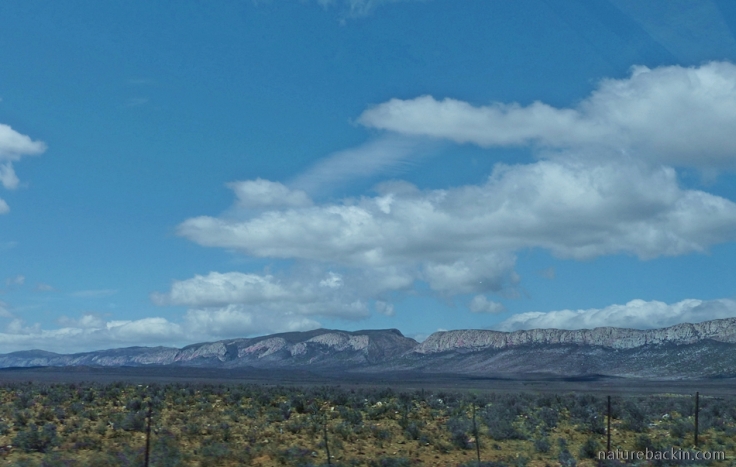
Part of the Swartberg mountain range seen from the road as we drove towards the mountains from the inland side
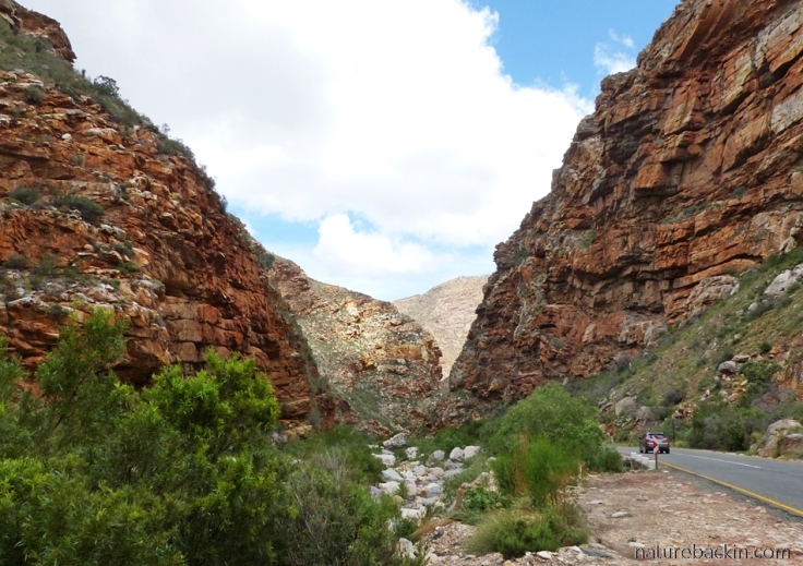
Of course several ways through the mountains have been found, with one of the most scenic being the Meiringspoort Pass that follows the course of the Groot River that makes it way down a narrow gorge providing a gateway through the Swartberg mountains.
Looking across from near the village of Klaarstroom to the top of Meiringspoort where a gap in the mountain range is visible

The village of Klaarstroom, situated near the top of the Meiringspoort pass, is named for the clear mountain streams that gave rise to a settlement there in 1777. After Meiringspoort Pass was opened up for the transportation of goods from the interior to Mossel Bay, a wool-washing facility was established using Klaarstroom’s clear waters to wash wool in transit from inland farms in the Great Karoo on route to the port. However, as can be seen in the above photo, the river bed at the causeway is completely dry
The first road through the pass was built in the 1850s and it was an important route for the transportation of wool and other goods intended for export. For more on the history of the building of the Meiringspoort pass – and its rebuilding after several significant floods – see here
Meiringspoort is interesting not only for the engineering of the road – the 16 kilometre pass crosses and re-crosses the river 25 times at low-level drifts – but also for the spectacular rock formations and the diversity of vegetation that grows in the different soil types that occur in the gorge
After descending the Meiringspoort pass we travelled via Oudtshoorn, the main centre of the ostrich farming district where ostriches have been farmed since the 1880s, initially largely for their feathers, but since the early 20th century more for meat and leather products, and less so for feathers. We were heading for the Gamkaberg Nature Reserve were we were to stay a couple of days, and on the way we passed through ostrich farming areas where the drought was all too apparent.
Passing through ostrich farms on the way to Gamkaberg, we saw that most of the paddocks on the ostrich farms were empty. The clouds brought a tantalizing smidgen of evening rain but not enough to even wet the ground
An article in GroundUp by Madison Yauger titled “Climate change plagues Western Cape agriculture” (6 November 2019, https://www.groundup.org.za/article/climate-change-decimates-western-cape-agriculture/) reports that Oudtshoorn farmers say the drought is costing them billions. They are unable to irrigate to grow lucerne, and ostrich production numbers have dropped by 60 000 birds over the past few years since the ongoing drought started biting in 2014. Many farmworkers have been laid off and farmers struggle to survive financially.
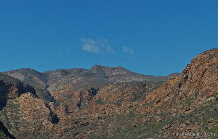
The Paardeberg mountains as seen while travelling through the Huisrivier Pass
After our stay at Gamkaberg Nature Reserve (which I will write about in another post) we continued on our journey, driving the Huisrivier Pass between Calitzdorp and Ladismith. Interestingly, the word “huis” in the name of the pass is not from the Afrikaans word for “house” but from the Khoi word for “willow tree”. For more on the Huisrivier Pass see here
Another notable pass as the road descends further towards Riversdale (and to the coast beyond) is Garcia’s Pass – another pass where the rock formations of the Cape Fold mountains are clearly visible to the traveller
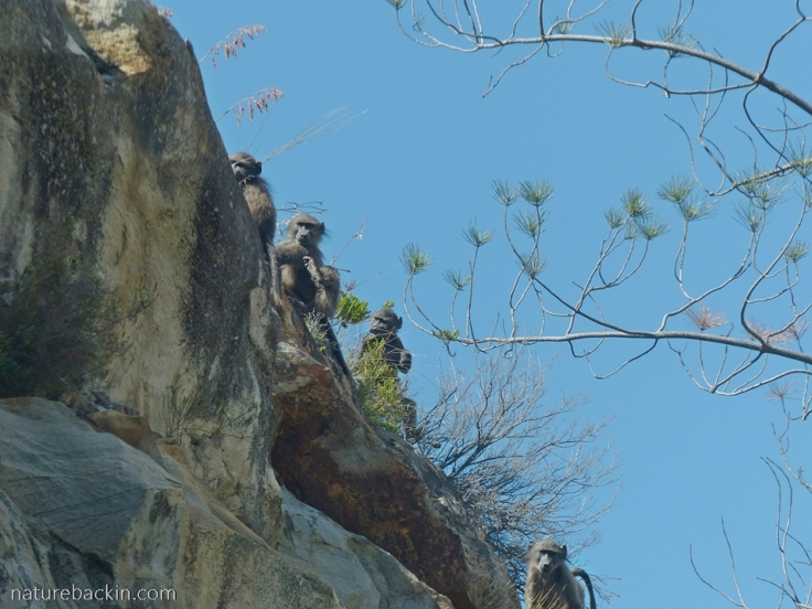
The mountains provide refuge for baboons. These baboons watched us warily when we pulled over to the side of the road on Garcia’s Pass
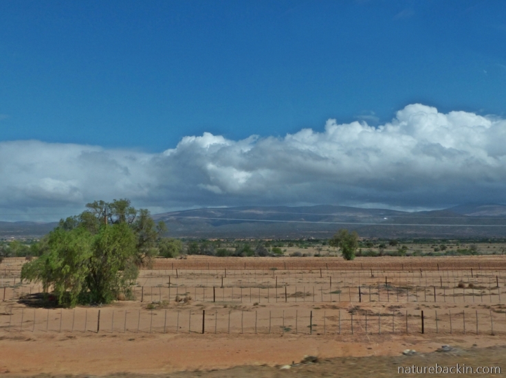
After Riversdale, as we continued travelling due west into the Western Cape the land became less parched and rain clouds gathered. We skirted several scattered and localised showers of rain.
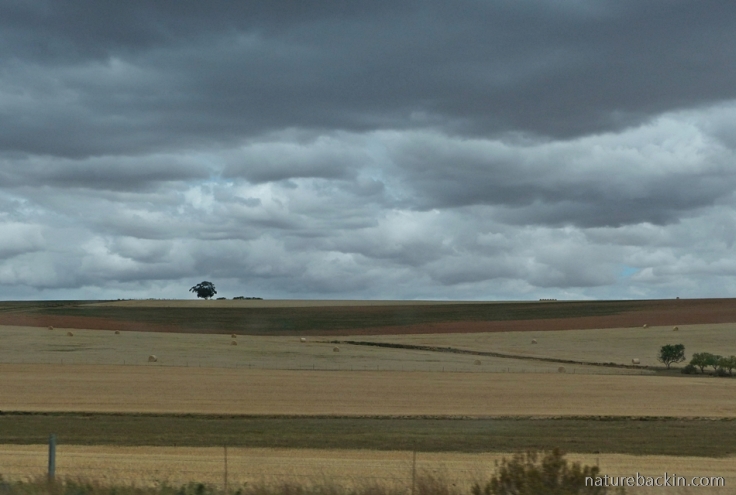
Hay fields make a golden contrast to the silver of the threatening clouds, as we drove towards Riviersonderend
A day or so after our arrival in Onrus near Hermanus, there was indeed heavy rain – enough to cause some localised flooding in some urban areas as stormwater drains blocked up. The rain was most welcome and sorely needed and it has boosted some of the dams in the region slightly.
However, water restrictions of varying degrees of stringency still remain in place in much of the Western Cape, including in Cape Town. Although the situation in Cape Town is no longer in crisis as it was in early 2018 when the dams were so low the city nearly ran out of water, current water restrictions limit personal usage of water to a maximum of 105 litres per person per day. Other restrictions include strict limits on the use of hosepipes.
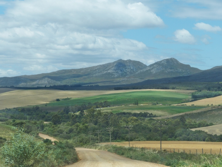
Inland from Hermanus on a day trip into the countryside it was a relief to see the relatively greener pastures after witnessing the dire circumstances in the Karoo
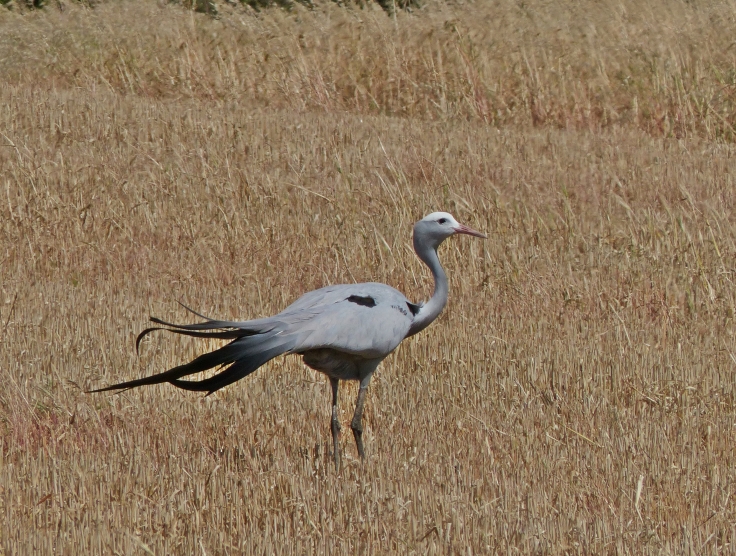
It was lovely also to see Blue Cranes in some of the fields – this one having its tail feathers tousled by buffeting winds
After our stay in Onrus, on our return trip home we travelled a different road back through the Karoo. Unfortunately there was no respite from the drought on this route either.
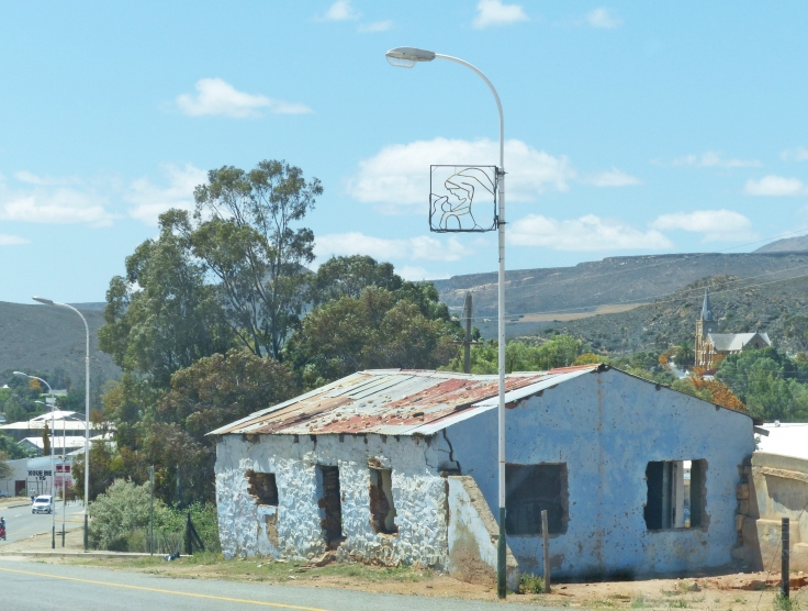
Entering the small town of Uniondale I photographed this abandoned building by the main road and I wondered if the Christmas light on the lamp post had been put up early for this year’s festive season or if it was left over from previous years? The town’s large Dutch Reformed Church can be seen in the distance to the right of the photograph
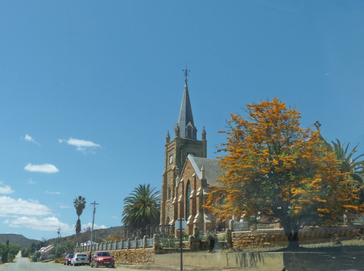
Here is a closer view of Uniondale’s Dutch Reformed Church, which was built in 1884. Most Karoo small towns (dorpies) are dominated by a central church

Uniondale is a small agricultural town that was founded in 1856 when it became known for its wagon building and ostrich feather industries. Even from a distance the church spire remains visible. The town is surrounded by the Kamanassie and Kouga Mountains

After leaving Willowmore the rock formations in the nearby mountains reminded me of the triangular shapes of toasted sandwiches served to travellers at quick-stop cafés on motorways

A typical Karoo farm landscape photographed as we approached Graaff-Reinet

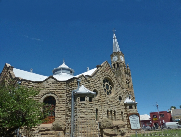
The main road cuts through the town of Graaff-Reinet with its impressive church, the Groot Kerk, built in the 1880s and inspired (I nearly missed the pun!) by Salisbury Cathedral in England

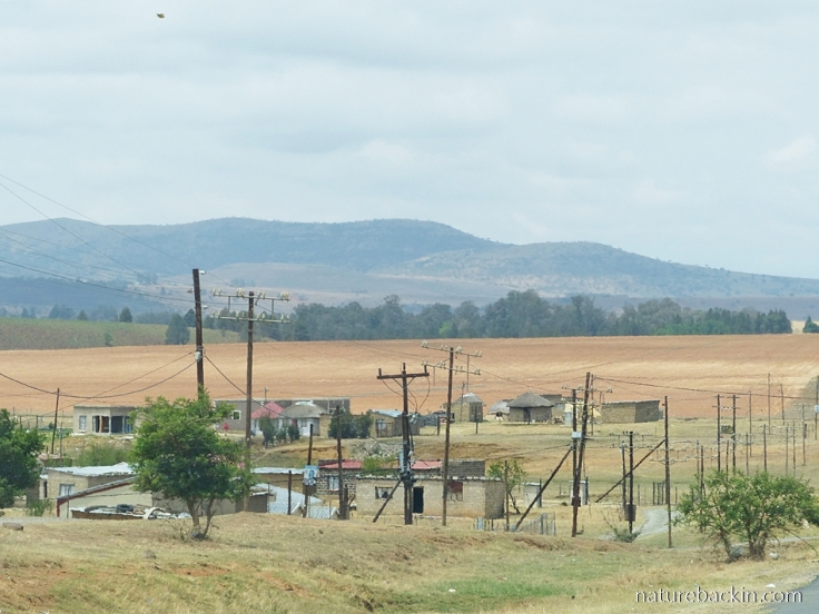
On the outskirts of Graaff-Reinet and hugging the main road is the uMasizakhe township, not far from the dry Nqweba Dam and Camdeboo National Park where we stayed for a couple of nights. Currently in ongoing crisis, the township relies on deliveries of water by tanker or donations of bottled water as the taps have run dry. For more on the water crisis see here
After leaving Graaff-Reinet and Camdeboo National Park (which I will write about in another post) we continued on our journey, leaving the Karoo and travelling through the Free State province north of Lesotho on our way back to KwaZulu-Natal.
Passing through the town of Burgersdorp I snapped this photo of the splendid Dutch Reformed Church that was built in about 1912

Overlooking Burgersdorp is this Block House or small fort, one of many built by the British during the Anglo Boer War (1899-1902) and used in the defence of railway lines and bridges
Getting closer to home we passed through the Golden Gate National Park in the foothills of the Maluti Mountains that are part of the Drakensberg mountain range. The park is famous for its towering sandstone cliffs and rock faces. The willow trees (an introduced species) provide an illusion of lushness in a landscape that remains dry despite some recent light rains
Usually when we cross back into KwaZulu-Natal we are greeted by a pleasing verdancy. But not this spring. This settlement is near Bergville, and the veld is dry and there has not yet been sufficient rain to plant in the fields
And so after our long road trip, we got home to mostly cooler temperatures and forecasts of continuing light rain. After the sobering experience of driving through extreme drought conditions in the Free State and in the Eastern Cape, we better understand how fortunate we are here at home, where we still have water in our municipal water supply dams, our home rainwater tanks are full and we have the promise of rain.
If you are interested in getting an idea of our route, I copy a rather basic map below. The numbers indicate the places where we stayed or stopped over for at least one night.

Now that we are settled back home, I look forward to catching up on at least some of what I have been missing in the blogosphere while we were away.
Posted by Carol


November 15, 2019 at 10:50 pm
Interesting… it seems we were both thinking the same about giving a general feel for a larger area where we traveled. I had just barely begun my next post in which I planned to feature shots mostly taken through the windshield. Unfortunately a truly nasty cold stopped me in my tracks, but I think I may be recovering enough to finish it in the near future (I hope!)
I had some doubts about presenting images taken as we drove along (I never drive the pickup, preferring to be behind the wheel of my much smaller vehicle), but you certainly captured that general impression that I had been hoping to convey. You succeeded far better than I did in avoiding the glare of the reflected sun on the glass. I applaud your success in giving us ‘foreigners’ a glimpse of your countryside. There are some similarities to what we seen here, but your drought looks far more severe than ours.
Hoping for rain and relief wherever it’s needed the most!
LikeLiked by 1 person
November 19, 2019 at 12:53 pm
Thanks Gunta – what a coincidence that we went on trips at about the same time, and to arid regions, although were we went though arid is not desert proper, although the prolonged drought may make it seem so …
I have a weakness for taking photos while on the move. Although most of them are complete fails there are a few that are acceptable enough and it is a great way to record the scale and variation of the landscapes one travels through and that sense of being on the road. I avoid taking pictures when the glare from the light on the window glass is too pronounced, but glare (and dirt on the glass) can’t always be avoided.
I hope that you are recovering from your nasty illness, but try to take it easy as much as you can as you start to feel better. In good time when you feel like posting again I look forward to seeing more of your fantastic photos of your trip.
LikeLike
November 12, 2019 at 2:48 am
Hi Carol, Thoroughly enjoyed your photos and narrative of your road trip. Agree with Eliza that some of the landscapes are like the Southwest in the US but the rock formations in the pass, the baboons and the blue crane are quite different than what we would spot here. 🙂 We all have drought and rising temps in common…it’s frightening. On a cheerier note, we loved our trip to South Africa and enjoyed Cape Town very much.
LikeLiked by 1 person
November 14, 2019 at 6:54 pm
Thank you so much Jane. The extreme weather patterns are unnerving at least and devastating in so many regions – frightening as you say.
I am glad you enjoyed your trip to South Africa. Cape Town is a unique place.
LikeLiked by 1 person
November 11, 2019 at 7:36 am
Wow Carol, what a lovely post. Enjoyed your informative descriptions of the passes, and the lovely pics as always – even if from a car window. Also enjoyed the snippets about the little dorpies , the architecture and the ongoing sad state of the drought a real eye opener. KZN seems to have not been as badly affected as the Western Cape. Loved the baboons, so typical of them perched on the rocks like that, gorgeous pic.
LikeLiked by 1 person
November 11, 2019 at 9:07 pm
Thanks very much Carol. Those Karoo dorpies are so interesting. Although we were aware of the drought it was still shocking to actually see how bad it is. We have been relatively fortunate at least in some parts of KZN, and of course now some parts of the country are having heavy rain. Must make the drought even harder to bear for those still without rain.
LikeLiked by 1 person
November 10, 2019 at 8:14 pm
What an interesting post. How do they monitor personal water usage – does it get cut off when the limit is up? The pictures remind me of Patagonia. But the photos of the deserted farm and the cattle warning sign also bring to mind a certain end-of-the-world mood. Looks like something bad happened and no one stayed but the baboons, looking at rare passing visitors with wonder.
LikeLiked by 1 person
November 11, 2019 at 9:05 pm
As far as I know, in Cape Town in fact it is household (not personal) usage that is monitored. Tariffs increase for higher water users, and those who exceed limits are fined. Some households have had smart water meters installed. Water pressure in the system has been reduced and flow restriction mechanisms have been installed to reduce consumption.
It is interesting that the Cape landscapes remind you of Patagonia. I love your observations about the sense of something almost apocalyptic going on under the scrutiny of the baboons.
LikeLiked by 1 person
November 9, 2019 at 12:50 pm
Thanks for sharing your trip. I think the photographs are excellent
LikeLiked by 1 person
November 11, 2019 at 8:24 pm
Thanks for your kind comment Mariss.
LikeLiked by 1 person
November 9, 2019 at 11:39 am
Amongst other things, your post has augmented my sense of the size of South Africa. I have only visited Mpumalanga – such a tiny part of the whole. The drought is worrying and again, you’ve offered a sense of scale of the size of the affected area. Despite the drought concerns, I hope you enjoyed your road trip, Carol 🙂
LikeLiked by 1 person
November 11, 2019 at 8:23 pm
I have become a bit obsessive at looking at weather forecasts for the drought-stricken areas. Not much good news there, though other parts of the country, including here, are now having heavy rains.
We had an interesting trip thanks and enjoyed our stay with an old friend.
LikeLiked by 1 person
November 9, 2019 at 5:31 am
What an interesting road trip. I look forward to hearing more about the different places you visited. The drought is just awful. Ironically, we have had an unseasonable mini-drought here where the pastures of the local dairy farm are nothing more than brown, dusty dirt. But here there are other irrigated fields that remain green and the drought itself is undoubtedly temporary. The endless one that you talk about must be nightmarish.
I must say, I like a good road trip and that’s one thing that really isn’t available here. A couple of hundred miles will get you around the entire island!
LikeLiked by 1 person
November 11, 2019 at 8:20 pm
I hope that your drought is indeed temporary. The Karoo and Eastern Cape and other regions continue to be nightmarishly dry, but now other parts of the country, including where we are, are having heavy rain! There is even a flood warning for the southern coast in the Western Cape.
Well islands have other compensations 🙂
LikeLiked by 1 person
November 12, 2019 at 6:08 am
It is raining here even as I type. But this is the way of weather – drought followed by floods followed by fires and who knows what else. I hope things mellow out soon.
LikeLiked by 1 person
November 14, 2019 at 7:02 pm
Glad you are getting some rain. Things not mellowed out here yet. There was even a damaging tornado in the region coupled with continuing heavy rains, while the drought in the interior of the west of the country continues with no relief in sight …
LikeLiked by 1 person
November 15, 2019 at 6:22 am
Weather is a fickle beast, that’s for sure.
LikeLiked by 1 person
November 8, 2019 at 8:01 pm
4000 km, that’s really a lot! It is interesting to see some European buildings in this place that seems strange to me. And as you know, I love your pictures of the fascinating rocks!
I hope you’re enjoying the rain like I am right now. 😊
LikeLiked by 1 person
November 11, 2019 at 4:41 pm
Glad you also enjoy the rock formations 🙂
And talking of rain – in the last few days we have had lots of heavy rain!! Unfortunately the drought-stricken areas in Eastern Cape and the Karoo have had none, but here in our region we have even more rain scheduled – it never rains but it pours it seems …
LikeLiked by 1 person
November 8, 2019 at 9:47 am
Such interesting pics of some similar routes we travelled through from Onrus (where we live) to Kwazulu Natal (where you live) and back to Onrus, in September. It was also wonderful and a privilege to meet you for coffee at a small restaurant right on Onrus beach. You were here only for a couple of days so I really appreciate the two hours we could spend together with interesting stories to share. Thanks Carol!
LikeLiked by 1 person
November 8, 2019 at 7:25 pm
Thanks Suzette, and it was great to meet up at Onrus and to have coffee and catch up while looking out over the lagoon and the beach and the welcome rain, and thank you for making the time 🙂
I hope that you enjoy sharing beautiful Onrus with all the visitors over the holiday season!
LikeLike
November 8, 2019 at 9:02 am
These landscapes are so unfamiliar to me from my European perspective. The drought you write about is worrying, and I read about it just as I heard the news about severe flooding not so very far from where I live in the UK. We’re all having to contend with a new abnormal that will be hard to accommodate. Nevertheless, I’m really looking forward to reading about and seeing more of your road trip.
LikeLiked by 1 person
November 8, 2019 at 7:19 pm
Sorry to hear about the severe flooding in your region. The new abnormal is indeed becoming widespread and this new reality is here and now much sooner and more extreme than perhaps many of us expected. That future time we were fearing is now already here.
And thanks – I will be posting more about our trip.
LikeLiked by 1 person
November 8, 2019 at 4:03 am
Your photographs provide a good overview of the crisis much of South Africa is facing. I had to smile ruefully when I came across a municipal notice from last year restricting us to 100l water per person per day – we are down to 25l per person per day with no rain in sight. There are no signs of agricultural planting around here and the grazing for both wild and domestic animals is down to bowling green level. Your trip covered interesting places that are familiar to me – I hope you enjoyed a good break.
LikeLiked by 1 person
November 8, 2019 at 7:14 pm
Thank you Anne we had an interesting break that is for sure.
I quite often check the weather forecast for Makhanda/Grahamstown and it is never encouraging. I really feel for your predicament – 25 litres a day is very hard to manage on for a long period – never mind for an indefinite period of time.
The hardships facing people as well as animals is tough to witness when travelling by as we were. Having to live permanently in such tough circumstances is beyond tough and must be incredibly stressful.
LikeLike
November 8, 2019 at 2:07 am
And I’m so hungry for padkos right now! 😀
LikeLiked by 1 person
November 8, 2019 at 7:06 pm
🙂
LikeLike
November 8, 2019 at 2:07 am
Welcome back, Carol!
I can’t tell you how much I’m looking forward to more of your photos and impressions from this trip; you’ve visited a few of our favourite places and some others still on our bucket list.
Sad to see such large swathes of our country still suffering through drought though.
LikeLiked by 1 person
November 8, 2019 at 7:05 pm
Thanks very much. We had an interesting trip but it is good to be back home, and yesterday we had fabulous soaking rain. We are just so fortunate.
I will be posting about some of the places we visited. Next up will be the fascinating Gamkaberg.
LikeLiked by 1 person
November 9, 2019 at 2:34 am
Wonderful to hear that the rains have reached PMB!
Looking forward to more about Gamkaberg, Carol – I hope you got to see the mountain zebras.
LikeLiked by 1 person
November 11, 2019 at 8:11 pm
Yes – crazy weather system currently! We continue to have heavy rain. I think Pretoria might be getting a little rain?
We did not see the mountain zebras this visit, but we did see them at Camdeboo.
LikeLiked by 1 person
November 12, 2019 at 2:39 am
We woke up to a lovely shower Sunday morning and the clouds are hanging around, so we are hoping for more. Sad to see the devastation caused by flooding around Durban on the news, and in the same bulletin the devastation caused by the drought in the Karoo and other areas.
LikeLiked by 1 person
November 14, 2019 at 6:52 pm
Good that you have had some rain and nothing too extreme as yet compared to other places.
LikeLiked by 1 person
November 15, 2019 at 1:28 am
We saw yesterday how hard the Zululand game reserves have been hit by the downpours that have already wreaked havoc on PMB and DBN
LikeLiked by 1 person
November 15, 2019 at 1:48 pm
The rain is continuing, though here at least less heavy today. The destruction has been very sad. In that tornado near New Hanover 2 people were killed and apparently 200 homes were destroyed, and it is even harder to start trying to rebuild when the weather remains extreme and unpredictable. And with all the rain here, the drought in the Karoo and adjacent areas continues unabated …
LikeLiked by 1 person
November 16, 2019 at 2:45 am
I’m finding our weather much harder to fathom these days than when I was taught about it in standard 2 many years ago…
LikeLiked by 1 person
November 19, 2019 at 12:54 pm
Definitely. It seemed to be so much more predictable back then.
LikeLiked by 1 person
November 8, 2019 at 1:11 am
So much of these landscapes remind me of the American Southwest. Similar climates. The drought there seems to go on and on. California’s lasted 7 years before last winter’s decent rain. Of course, the wildfires there are now raging through the brush that the rain spawned which dried over the summer.
LikeLiked by 2 people
November 8, 2019 at 7:03 pm
Thanks Eliza – interesting those similarities, not least the ongoing droughts.
Those fires in California are incredible.
LikeLiked by 1 person
November 8, 2019 at 7:06 pm
Indeed. Quite nightmarish.
LikeLiked by 2 people
November 8, 2019 at 7:33 pm
Absolutely nightmarish, and daunting too that much of the fire season is still to come.
And now we are hearing of the current emergency with raging fires in Australia …
LikeLiked by 1 person
November 8, 2019 at 7:39 pm
Mother Earth is sending a message, methinks. BTW, today is the one-year anniversary of the Paradise Fire which killed 186 people, the worst in CA history. 😦
LikeLiked by 2 people
November 8, 2019 at 7:56 pm
What a topical anniversary – thanks I will look up the history of this awful fire.
LikeLike
November 9, 2019 at 12:05 am
I’ve been following Gary’s blog since the fire (he talks about his experience in Paradise last year, he was one of the lucky ones to get out, but the scars remain). He seems to have deleted most of his posts prior to October, not sure why. https://anotherpictureonthewall.com/2019/10/31/an-interview-with-me/
LikeLiked by 1 person
November 11, 2019 at 8:07 pm
Thanks very much for this link Eliza. I read all the interviews in the university newsletter and it really gives such an intimate perspective into what happened and the aftermath of the fire for those survivors, which newspaper reports at the time, horrifying as they were, can’t convey.
LikeLike
November 11, 2019 at 9:39 pm
I agree, we seldom hear the personal stories, and those are the ones we relate to most. Glad you found the link helpful.
LikeLiked by 1 person