
I had been expecting to start posting again celebrating brighter, whiter sight after successful cataract surgery, but first intense storm surges along the coast and then the following week widespread flooding across the region, including a “100-year flood” in our village, surpassed all else.
Our house on higher ground was safe, but when the Klein River (translates from Afrikaans to ‘Small’ River) came down in a massive flood, many houses in the lower-lying parts of Stanford village were flooded – to ceiling height in houses closest to the river – and boats had to be deployed to rescue people trapped on ground floors or stranded on rooftops, in lofts or the upper floors of their homes.
This year, the winter had been far wetter than usual and the ground was saturated. More storms arrived in mid-September and circumstances combined with a spring tide led to massive storm surges and gale-force winds along the coast that caused damage to coastal infrastructure and, tragically, several people lost their lives.

Of course, we did not venture out to the coastal areas during the storm surge, but a few days later the seas were still high and dramatic. At other side of this bay, the mouth of the Klein River lagoon is just visible. The storm surge served to open the mouth of the lagoon wider still (the mouth had already been (illegally) breached artificially in May) and so water from the lagoon has been able to flow freely out into the ocean since May this year
Stanford village lies on the southern bank of the Klein River that flows to the Klein River lagoon six kilometres away. The lagoon is about 10 km long and at its widest point about 2 km wide. More often than not the lagoon mouth is closed to the ocean by a sandbar, but periodically this sandbar breaches naturally. But as mentioned in the caption, earlier this year the sandbar was breached artificially, impacting not only the lagoon, its birdlife and other creatures, but also further upstream including in Stanford: the level of the river flowing past Stanford dropped rapidly and significantly following the breaching incident. Below is a report from a local paper on the breaching incident at the lagoon in early May.


Source: https://fliphtml5.com/xkcxj/lzaf/THE_VILLAGE_NEWS_5_May_-_11_May_2023/
But getting back to more recent events in September, less than a week after the storm surges along the coast, the South African Weather Service issued warnings for widespread extreme rainfall, especially over much of the Western Cape and the western region of the Eastern Cape. In some areas the warnings of disruptive rains were upgraded to an unprecedented “Level 9” (in orange in the map below).

Sources: https://www.weathersa.co.za/ and https://www.meteoblue.com/
Obviously, we were anxious about such unprecedented warnings, though we were uncertain as to what the severity of the implications might be. Along with many others, we resolved to stay at home over the weekend of the 23 and 24 September when the “disruptive rains” were set to arrive. And the widespread rains coupled with strong winds did arrive, including in the mountains and catchment areas. Floods and/or mudslides affected many communities, villages and towns in parts of the Western and Eastern Cape.
Perhaps the maps (below), clipped from Google Earth and annotated by me, might make it easier to visualise what happened in Stanford to precipitate the “100-year flood” that had such stark consequences for those whose houses were flooded.
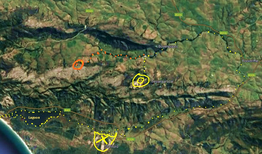
The approximate origin (orange bullseye) and the course of the Hartebees River (orange dots) are indicated on the above satellite map, before the Hartebees River meets the Klein River with its course indicated by yellow dots
In the above map as noted in the caption, the orange bullseye indicates the approximate start (at about 300 m above sea level) of the Hartebees River and the orange dots map its course to where it joins the Klein River (approximate origin indicated by yellow bullseye). From the confluence, the river is named the Klein River to where it flows into the lagoon. Three other rivers join the Klein River before it curves south (just to the west of the R326 road shown on the map) and then the river turns again to flow west (parallel to the Klein River mountains), past Stanford (marked by a yellow X), to the lagoon and then into the Atlantic Ocean (just south of Hermanus).
The total length of the Klein River is 80 km, but the distance between its origin and its mouth is only 5 km as the crow flies. The mountainous catchment areas of the river system extend over a combined 2002 km. Heavy rains over this terrain can contribute to significant increases in the volume of water in the river system, and a widespread deluge in a short period of time, especially after the ground is already saturated, quickly adds up to a huge amount of water (Klein River information from http://www.overberg.co.za/content/view/206/28/).
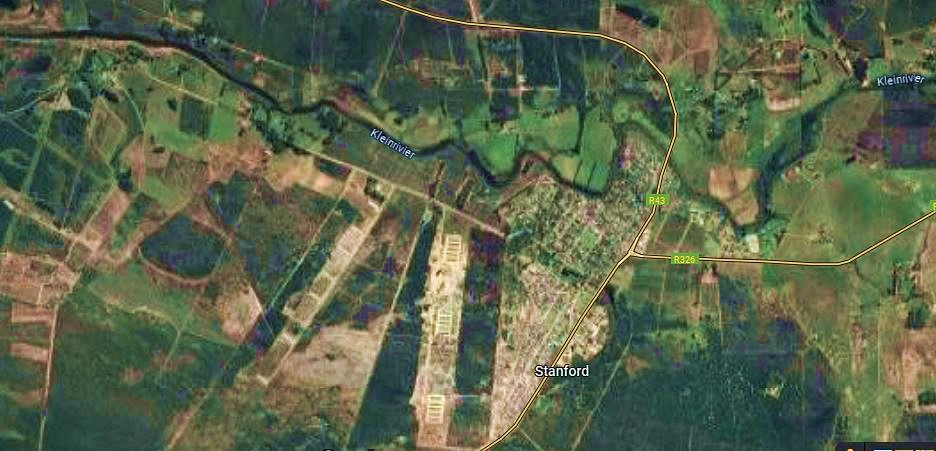
A closer satellite view of the Klein River where it flows past the village of Stanford
Disastrously, on that weekend in September the amount of rain that fell in the catchment areas was so enormous that the river burst its banks way before reaching Stanford. When the fast-flowing waters arrived on Monday morning, 25th September, over 65 houses in the lower lying parts of Stanford were flooded.
My initial impression of the floods was (literally) very one-sided as we were cut-off from the rest of the village by the usually small Mill Stream, which was inundated by water from the Klein River pushing up the course of the stream, rather than from the stream itself being in flood.

Above is a view of the Mill Stream taken in the morning when the flood waters were still quite high. Some houses along the usually small stream were flooded by waters from the Klein River that inundated the lower reaches of the stream by flooding upstream
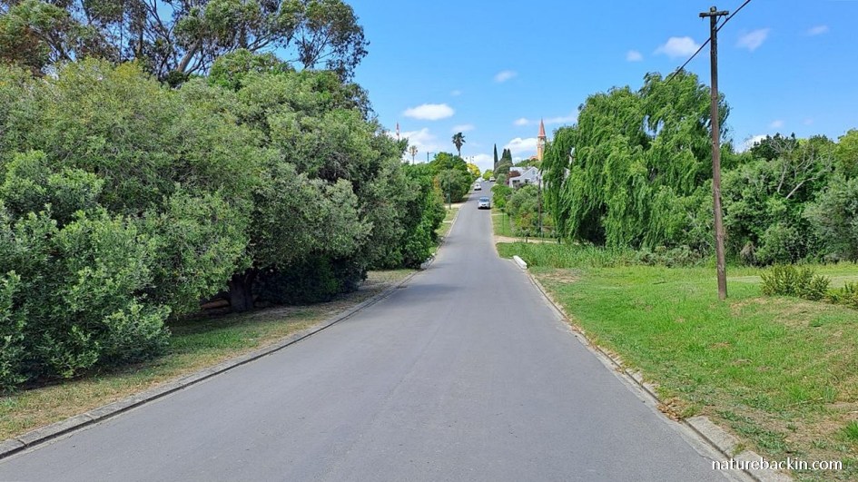
This is what the dip in the road and low-level bridge over the Mill Stream usually look like. The stream is flowing from right to left under the bridge and down to the Klein River

Another view of the road taken from higher ground. I took this photo on Monday evening, 25th September, when the flood waters had dropped considerably. The main part of the village is on the other side and adjacent to the low-lying part of the village that experienced the worst flooding
As we were cut-off, we had to rely on social media to learn that the Klein River at the height of the flood had overwhelmed the bridge on the main road (R43), which connects the village to Hermanus in one direction and Gansbaai in the other. This main road was closed during the flood.
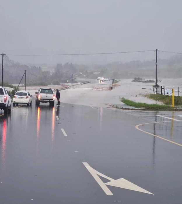
Above is an anonymous photo that was circulated on social media on the day of the flood when the bridge on the R43 was underwater from the Klein River in flood
Eventually, on that Monday morning after the rain had stopped and the water level of the river had started to drop, we ventured out to look at the river from high ground.
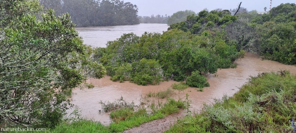
In the foreground is part of the Wandelpad walking trail, submerged by flood waters as it drops in height. The tops of trees adjacent to the lower path are sticking out of the water
In the video below, the river is still in flood although the level has dropped slightly since its height when over 65 Stanford houses upstream had been flooded. As can be seen, the river has burst its banks – the usual contour of the bank on the other side is indicated by the tree line. The water flow is fast and powerful.

The river flooded out into farmland on the other side. The bank on this side is elevated high above the level of the water.

The trees below the elevated bank are partially submerged by the flood water. The flooded houses are upstream of this section of the river
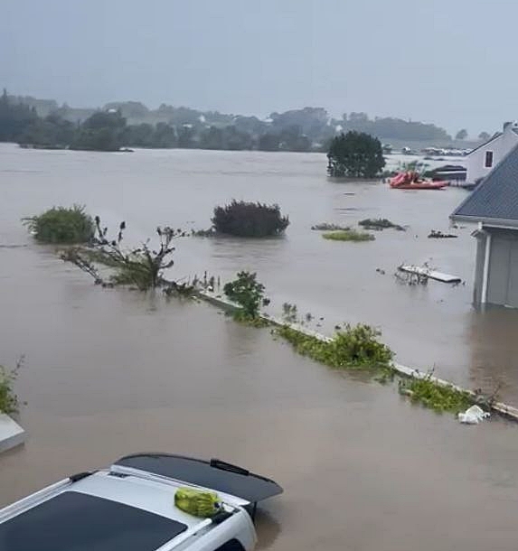
Astonishing footage of rescue operations by boat came out on social media. Here is an image clipped from one of the anonymous videos. In the background a red rubber-duck rescue boat can be seen approaching one of the flooded houses. A partially submerged car is in the foreground. Many cars were submerged while still parked in garages and yards as the waters rose too quickly for people to escape. It is estimated that well over 80 vehicles were written off

The above image is from a video that was shot from a small boat ferrying people rescued from their flooded houses to safety. Partially submerged houses can be seen in the background. Miraculously there was no loss of life, even all pets were rescued. Huge credit is due to all the rescuers that included community members, local emergency teams and National Sea Rescue Institute volunteers
Even though we were not directly affected, I find it hard to recount the aftermath of the flood. We helped for a few days at one of the flooded houses. As the flood water had swirled around inside flooded rooms as it tried to escape back into the river, the turbulent water floated, tipped over and mixed-up large pieces of furniture and appliances such as fridges, together with smaller items, causing total chaos and leaving everything saturated and coated in stinky mud.
Treasured items including cameras, books, art work, photographs and files of documents were destroyed, in addition to almost all electrical appliances being written off, and most soft furnishings and furniture, such as built-in cupboards, trashed. Some clothing, linen and blankets could be salvaged, but only after repeated laundering to remove the tenacious and smelly mud.

During clean-up, a small sample of trashed books in one of the flooded houses (above). The floors, window sills and all horizontal surfaces below the flood line were coated in dark, glutinous mud that hardened to a concrete-like consistency if left in place to dry. The smell of the mud and rapidly blooming mould was unpleasant and unhealthy to say the least
People who found themselves trapped in their houses as the river rose fast had to make quick life-or-death decisions. Some, in single storey-buildings were unable to open doors against the force of the flood waters and could not escape through burglar-proofed windows. They had to wait trapped inside, desperate to be rescued.
For many the trauma runs deep and the losses are profound. Houses that were flooded are still drying out two months after the flood. The process of recovery is slow and arduous, stressful and expensive. To date, most of the homes that were flooded are still not fit for occupation and a few more months of repair work will be necessary.
In the face of the disaster, the community did come together to help in many ways. More recently a national supermarket chain decided to step in and bring some good cheer and to tell the story of the Stanford flood and celebrate the spirit of community. It sponsored street banquets for those directly affected by the floods including the rescuers, and sponsored colourful Christmas lights of astonishing complexity and detail along the main street in the centre of the village.

The lights really do provide cheer to Stanford and also serve to attract visitors and bring trade to local entrepreneurs and businesses
Last week the monthly Stanford Sunset Market was greatly enhanced by the Christmas lights, drawing lots of visitors from far and wide, and the market on the village green spilled over into the main street on a balmy night of bonhomie.

Families thronged the main street in an atmosphere of cheerful calm

A pink rhino and on the right a blue giraffe browsing from a red tree brightened up a local restaurant

Among my favourites: attended by beadwork weaver birds, woven weavers’ nests in lights hang in one of the trees on the main street
Yesterday we had to visit a neighbouring town, and on the way back we stopped at a low-level bridge over the Klein River a few kilometres upstream of Stanford. The bridge has just been reopened after damaging washaways of the banks. The river is now a placidly moving small river, its water stained amber by tannins from plants leaching into the river, which is a characteristic of many rivers and streams in the region.

The river in flood washed away the approaches to the bridge. The embankments have now been rebuilt and reinforced

A view upstream from the bridge showing something of how much earth and sand was moved to rebuild the road and embankments
During the flood, the water in the river running wide, deep and fast as it passed over this bridge still had a further 10 km to travel to overwhelm the low-lying parts of Stanford. Many items from Stanford houses and gardens were carried away in the torrent. Some larger items were later recovered in the lagoon, but much else was washed out to sea. On social media, a photo of an upholstered dining chair that had been found washed up on a beach in Hermanus led to it being returned to its owner in Stanford. To my knowledge, the other dining chairs in the set were never found.

These three boats used for pleasure cruises down to the lagoon, are back at their damaged moorings in Stanford. They were washed away during the flood and a few days later they were recovered in the lagoon. The boardwalk and jetty need repair. On the far bank eucalyptus trees are still standing though with many branches broken. During the flood, branches sounded like gunshots going off as they snapped from the force of the water
Staying with the watery theme, and returning to the subject of my cataract surgery, I was surprised to read that the reason why eye cataracts are so named is because, ultimately, advanced cataracts develop into a white patch that noticeably covers the lens of the eye giving the eye a milky appearance, similar to the appearance of white water in an actual waterfall or cataract.
My cataracts were not advanced enough to be easily noticeable to someone observing my eyes, but they were clouding my vision with an amber stain. It is common for vision to be dulled by amber, brown or yellow colouration as cataracts develop in the lenses of the eye.
I only became aware of this amber discolouration after the surgery when I was amazed at how white and bright my sight had become. I was amused though that the association between eye cataracts and actual waterfalls was made even more appropriate by the amber colour of the water in local rivers and streams.

Amber-tinted waters of a local river

A representation of before and after cataract surgery – an amber-tinted image on the left and bright post-surgery vision on the right!
But as I said at the start of this post, for this village and its residents, almost all else has been surpassed by the flooding that took place in September. To sum it all up, I end with a link to the recently-released promotional video on the Stanford floods made by a national supermarket chain. Part of a marketing campaign it is, but it certainly does convey a lot about the floods that changed this village and the lives of many of its residents.
Posted by Carol

Discover more from letting nature back in
Subscribe to get the latest posts sent to your email.


December 3, 2023 at 4:34 pm
I was wondering how you are and was delighted to see your post in my social media box.
Thank you for this detailed and graphic account of the flooding of Stanford. A true deluge. The devastation it caused must have been terrible for those affected.
I am glad your house was ‘high and dry’ and that your sight is now white and bright
LikeLiked by 1 person
December 4, 2023 at 7:33 pm
Thanks Mariss – it has been devastating for those directly flooded, and sobering for the community as a whole. We are grateful our house was safe. And it is wonderful to have brighter sight too. Hope to catch up with your blog soon,
LikeLiked by 1 person
December 3, 2023 at 3:27 pm
I am absolutely relieved to hear from you, Carol. Having seen and read about the devastation of one of our country’s most beautiful coastal areas and knowing that you were right in the middle of it I truly feared that you were badly impacted, my concern only growing the longer you were “off air”.
It is wonderful to hear from you once more. You have done an amazing job of cataloguing what your new community has been put through. What a relief to know that none of your number were lost.
And thank goodness for cataract surgery that went well!
LikeLiked by 1 person
December 3, 2023 at 4:13 pm
Hallo Dries – thank you for your message and I am touched by your concern. We are grateful to have been safe. It has been confronting and distressing to hear firsthand of some people’s flood experiences, and to get an inkling of what they still need to deal with. It is such a huge relief to know that everyone here in Stanford at least was rescued.
This winter has been quite a season, and being our first experience of a wet winter it has taken a lot of adjusting, Despite it all, we continue to settle in and feel more at home.
I hope to be able to catch up with blogging more generally, especially now my vision is sorted including for reading, and I look forward to catching up with your posts.
Best wishes to you and yours from Stanford.
LikeLiked by 1 person
December 3, 2023 at 6:57 am
Dear Carol, although I was aware of, and seen footage of the flooding in the Western Cape, your article brings reality into perspective. As you say, although extremely frightening at the time, it’s the recovery that lingers long afterwards. My best wishes to your community. I’m delighted the view to your world is brighter, what a joy! Love and thoughts, xxx
LikeLiked by 1 person
December 3, 2023 at 3:59 pm
Hi Christeen – great to hear from you. It certainly is different to be so close to something like a flood or fire than reading about it from afar, as you well know. The aftermath is more easily overlooked from a distance. Thanks so much for your good wishes.
Best to you and also to KZN!
LikeLiked by 1 person
December 2, 2023 at 5:10 am
I am delighted that you are back! Apart from the coverage of the flood and high water, to me the most disastrous photograph is the interior of the house covered with that thick slick of mud.
LikeLiked by 1 person
December 2, 2023 at 9:33 am
Thanks Anne. I also think that the image of the muddy interior speaks volumes …
LikeLike
December 2, 2023 at 4:59 am
Yikes! Dramatic events indeed. Floods and fires happen so quickly and the impacts last long after they’re over. I’m glad you escaped the worst of it. Also glad your cataract surgery went well. I’ve known several people who’ve had it and it’s made a huge difference for them.
LikeLiked by 1 person
December 2, 2023 at 9:32 am
Hi Graham – indeed they happen so quickly and the aftermath is immense and long-lasting. Hawaii has had its share of such events too …
I have read a bit about the history of cataract surgery – not for the squeamish! Those of us with cataracts who are able to access the current more sophisticated surgery are very fortunate.
LikeLiked by 1 person
December 1, 2023 at 7:15 pm
What a frightening account of what you and your community has been through, Carol. Thankfully no loss of life but recovery from this trauma will be difficult. On a positive note, I’m glad your cataract surgery was successful.
LikeLiked by 1 person
December 2, 2023 at 8:53 am
Hi Jane – thanks for writing and yes it has been an incredible time. It is almost miraculous there was no loss of life, but of course the other losses can be profound, not least the loss of a sense of safety for those who were flooded.
And thanks re the cataract surgery – it has made a big difference.
Sending best wishes.
LikeLike
December 1, 2023 at 6:14 pm
This is seriously frightening news for your community if it’s what the New Normal will be like. Did you feel safe in your new home? Not a great start to your life there. I hope you remain happy with your decision to move. But so glad that your cataract op has been successful. Onwards and upwards!
LikeLiked by 1 person
December 2, 2023 at 8:49 am
Hi Margaret – our house is on high ground, but nevertheless the torrential rain and powerful wind was nerve-wracking.
There were and are numerous extreme weather events in the province we came from too, sadly. As there are all over the world as we all know.
Ironically this western side of the country where we are now is forecast to be entering a period of prolonged drought, and the eastern side where we came from is forecast to experience above average rains going forward!
Yes we do remain happy with our decision to move.
I hope your region has not experienced any particularly extreme weather events, though I have been reading on and off about storms and exceptionally cold snaps …
Keep warm and dry over the holiday period!
LikeLiked by 1 person
December 2, 2023 at 8:52 am
We’re not too badly off here, despite its being so c-o-l-d. But my daughter, living near Barcelona, is about to go into a period of severe water restrictions, with water being brought in by ship…
LikeLiked by 1 person
December 2, 2023 at 8:55 am
Glad that you are okay, but that is shocking about water having to be brought in by ship to the region near Barcelona. I wonder about Barcelona itself?
LikeLike
December 2, 2023 at 9:03 am
No, it’s Barcelona that may introduce these restrictions soon: if (and when) water reserves fall to below 16%. But my daughter only lives about 15 miles away so they are bound to be hit too.
LikeLiked by 1 person
December 2, 2023 at 9:26 am
What a nightmare having to ship in water for such a large city.
And I have just had a look at your temperatures – how absolutely frigid! I can’t imagine those temps. Sending warmest wishes.
LikeLiked by 1 person
December 2, 2023 at 9:39 am
Thank you. Warm wishes are what’s needed!
LikeLike
December 2, 2023 at 9:45 am
👍
LikeLike
December 1, 2023 at 6:07 pm
Wow, what a dramatic situation that arose so quickly. These ‘100-yr.’ floods I worry may happen more often with CC. Rather scary. We, too, had record-breaking rains in July, leading to floods and lots of crop losses for local farmers living along the flooded rivers. The damage in our little town alone resulted in a bill of $3.9 millionUSD for fixing the roads alone. That’s about 4x our total yearly budget. We’re struggling to find govt. help, but it is meeting lots of roadblocks.
I’m glad your cataract surgery went well, sight is a blessed gift!
Happy Holidays, Carol!
LikeLiked by 1 person
December 2, 2023 at 8:42 am
Hallo Eliza – I am so sorry to hear (though only now) about the record-breaking floods your region had in July. Farming is tough at the best of time so those massive crop losses are devastating. Also the costs of damage to infrastructure add up so quickly and so often results in funds being diverted from other necessary services. I hope your community does obtain govt. assistance with funding the repairs.
I hope your property was not badly affected by the flood? I agree with your concern that so-called ‘100-year floods’ may become rather more frequent.
True, sight is incredibly precious.
Happy Holidays to you too – it is hard to believe December is already here!
LikeLiked by 1 person
December 2, 2023 at 2:14 pm
🙏🏼
LikeLike
December 1, 2023 at 5:58 pm
Carol, it is so good to hear from you and to know that you are safe and well but my goodness, what a trauma for your community. Your words and photos combine to bring an immediacy to the event; I found myself caught up in the fear. Thank you too, for posting the commercial. In the UK Christmas ads are much anticipated and frequently carry messages of togetherness, hope, love. But there has never been one to my knowledge using footage from real events. It’s very powerful. At the most challenging of times, communities pull together.
On a personal level, I am glad your surgery has been successful. How lovely that you can once again experience the sights of your beautiful world so vividly! (I shall need similar operations in due course. And I’m aware that colours are already less vibrant than they once were. My turn will come.) Good to have you back.
LikeLiked by 1 person
December 2, 2023 at 8:37 am
I think living in a small community means that events are share with a greater intensity. They are more diffused in larger towns perhaps.
That is in interesting observation that Christmas ads are usually very generic rather than revolving around an actual event as was the case with the Stanford video.
Good luck for when your time comes for cataract surgery. It is a rather miraculous intervention and procedure, for which I am most grateful.
LikeLiked by 1 person
December 1, 2023 at 5:27 pm
Carol, I’m glad that you and your family are safe and well. What a heartbreaking experience, so much loss, my heart and prayers go out to Stanford. For many years I lived in Florida where devastating floods and weather related tragedies are common. At times I drove through water on the streets so high it came up over the front of my car. I hope that the man-made breech of the lagoon is repaired, along with all of the damage to homes, roads and bridges. Where do all of those people stay while their homes dry out for repair or replacement? What a difference in your vision, congratulations on your successful surgery. Blessings to you and all of the people in Stanford.
LikeLiked by 1 person
December 2, 2023 at 8:33 am
It is especially tough to live in a region such as Florida where people are vulnerable to ongoing extreme weather events, year after year.
Thanks Laura for your good wishes for Stanford, and best wishes to you.
The lagoon will take its natural course as it does after a natural breach. The damage to buildings, bridges, roads and other infrastructure across the region has been daunting and repairs are ongoing.
Yes finding alternative accommodation has been very difficult for many, esp as there is a shortage of available accommodation. Many local residents have opened their home to those affected, at least in the shorter term.
And thanks, how lucky to live in a time and place where cataract surgery is possible.
LikeLiked by 1 person
December 1, 2023 at 4:46 pm
My heart goes out to all those people whose homes were wrecked. When my former hometown flooded badly in 2007, people worst affected had to wait 12 and more months before their homes dried out, and could be repaired. It left them badly shocked for a long time afterwards. The Klein River deluge looked utterly alarming, but what resilience the community mustered. The Sunset Market looked a total spirit-lifter. Also v. good news about the success of your cataract op, Carol.
LikeLiked by 1 person
December 2, 2023 at 8:23 am
Previously, when hearing news of floods I tended to think about the immediate loss and not think of the lengthy aftermath. Waiting over a year is extremely tough, and expensive too including finding alternative accommodation. People are resilient but there is still a lot to come to terms with after such a disaster.
And thanks, it is great having brighter sight. Sending best wishes.
LikeLiked by 1 person
December 2, 2023 at 7:37 pm
Many thanks for the good wishes 🙂
LikeLike
December 1, 2023 at 4:40 pm
Hooray !!!! and good wishes.
John
LikeLike
December 2, 2023 at 8:18 am
Thanks John – and best to you too.
LikeLike