It is a month since the peak of the most recent of the wildfires that raged in our district. Ironically, after the intense heat and dryness, this week a cut-off low weather system brought unseasonal deluges of rain, heavy enough to cause flooding in some communities.
But back to the fires. In our Mediterranean climate here in the Western Cape (summer is our dry season), this season has been hotter and even drier than average. Combined with several other factors including the presence of blustery winds, conditions for wildfires have been optimal.
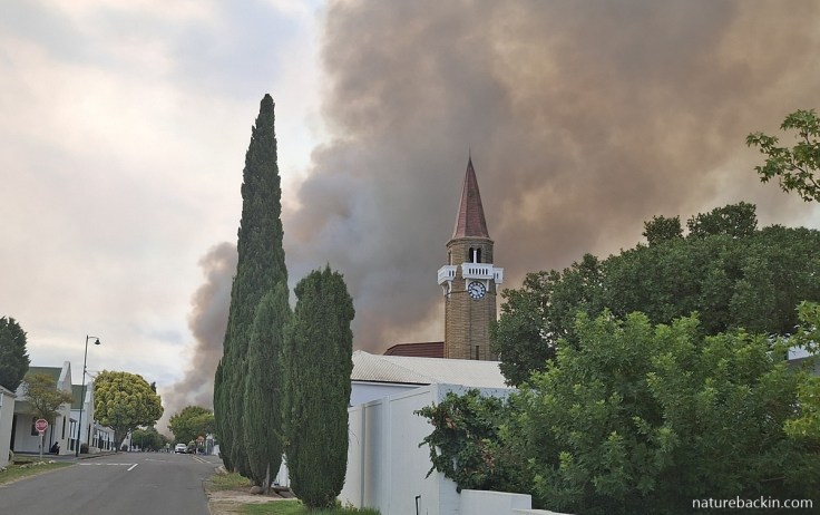
The main street in Stanford with a background of smoke, during a fire in January 2026
In a formal briefing on 22 January 2026, the Western Cape Provincial authorities said that this fire season “has recorded double the number of fires compared to the same period under review in the previous season, placing immense pressure on firefighting resources across the province”.
Officially, our fire season starts in December. But this season’s first major fire near where I live (in Stanford in the Overstrand Municipality in the Overberg) began in late October. The Provincial Premier said at the briefing that the 2025/26 fire season has been one of the most severe in a decade, with approximately 132 000 hectares of land having been burnt in the Western Cape province. He noted that across the province multiple structures have been destroyed,and the wildlife death toll has been huge. However, “there have been no human fatalities, a testament to the coordinated efforts of emergency services and disaster management teams”. (For more detail regarding this briefing see here.)
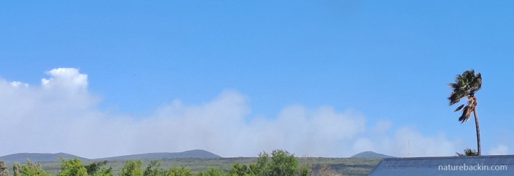
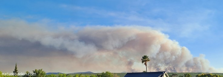
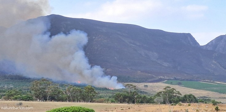
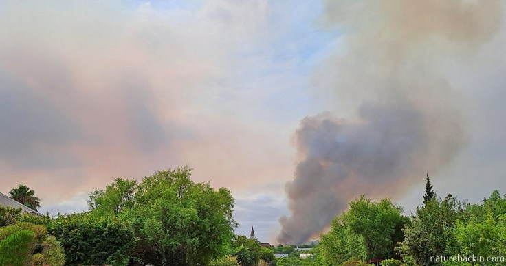
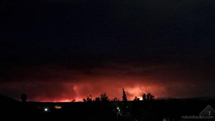
Visible from our window, rising smoke along the horizon from the Mountain Gansbaai Fire that was burning over 10 km (6 miles) away, 27 October 2025
I have been wanting to write a blog post about the weeks of fire that we have experienced since late October, 2025, but have not been sure how to tackle it. There have been many devastating fires across the province, including in the Winelands, near Mossel Bay and elsewhere, in addition to the fires closer to home in the Overberg. There have also been devastating fires in places in the Eastern Cape province. In this post I focus on the fires from late October 2025 to mid-January 2026, where billowing smoke if not the flames themselves were visible from our windows.
In this region fire is to be expected. Afterall, the naturally occurring fynbos vegetation is adapted to fire, with many species relying on fire for regeneration, but wildfires are increasingly destructive and increasingly frequent.
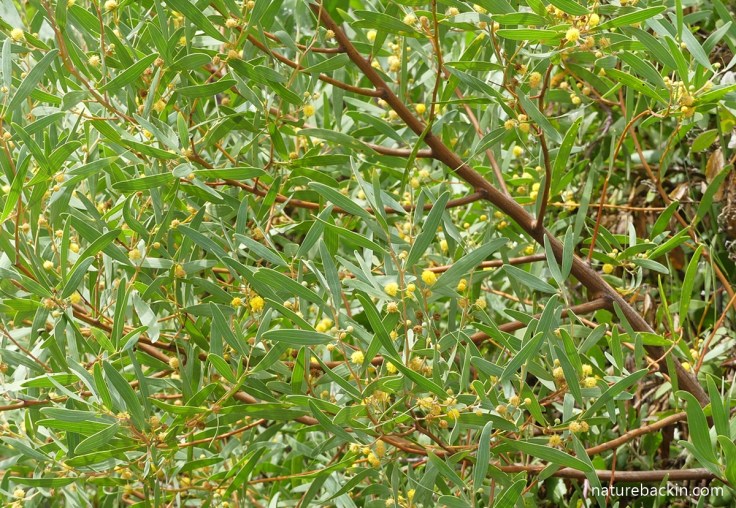
Rooikrans (Acacia cyclops) an invasive alien plant that grows bigger and taller than fynbos plants and can form dense thickets that are highly flammable
With the advent of large-scale agriculture and increasing urban development the landscape has been transformed and fragmented. Consequently, naturally occurring fynbos is no longer the dominant vegetation type and along with these changes there is the increasing presence of invasive alien vegetation. Alien plants such as rooikrans (Acacia cyclops) and Port Jackson willow (Acacia saligna) can give rise to hotter fires due to their flammable oils and greater biomass relative to the fynbos. The heat and density of this vegetation make extinguishing fires very difficult, and in addition thickets of alien vegetation can continue to smoulder undetected for a long time, raising the chances of flare-ups. Climate change, as elsewhere in the world, is another factor in the increasing the severity and frequency of wildfires.
Human or human-related activities (that range from arson, careless/inadvertent starting of fires—such as discarding lit cigarette butts, burning old electrical power cables to salvage the copper cores, burning rubbish, and even smoking-out beehives—through to accidents such as motor vehicles catching alight or power cables touching in high wind) are the biggest cause of fires. Discarded glass bottles in sunlight near flammable material can also cause fires. Natural causes of fire include lightning strikes.
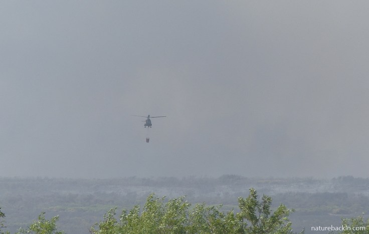
🔥The Mountain Gansbaai Fire 25 October 2025
The fire that started in the mountains near Gansbaai in late October was driven by strong winds. Access to fight the fire was difficult due to dense vegetation and mountain terrain. The fire spread rapidly and late in the evening, guests at the lodge at Grootbos Nature Reserve were evacuated for their safety on 25th October.
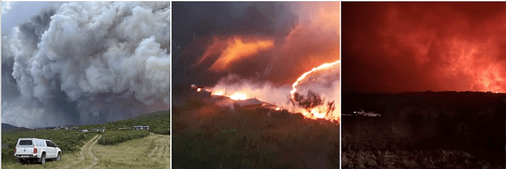
Above photos posted on Facebook, 25 October 2025, by the Overstrand Municipality in its update on the Mountain Gansbaai Fire. The Overstrand Municipality based in Hermanus issued daily fire updates (For the full update reports for the day see here)
Over the next few days, ground crews fighting the fires day and night and supported during the daylight hours by helicopters dropping water, heroically diverted the fire away from farm structures while struggling to contain the fire. Flare-ups continued over the week and due to smoke and hazardous conditions several roads, including the main road between Stanford and Gansbaai, had to be closed as the fires burnt close by or even jumped the roads.
The municipality’s report on the 1 November, noted that “Alien vegetation remains a serious problem and poses a significant challenge to effective fire management. Landowners are encouraged to develop an alien vegetation management plan for their properties and to establish and maintain proper firebreaks. In the fynbos areas, the fire lines are cold.”
The ongoing management of hotspots was helped by the almost miraculous onset of cooler weather in the first week of November, but mop-up operations along the perimeter continued into early November.
Platbos Forest Reserve
In August 2025, I posted on naturebackin about Platbos Forest, southern Africa’s southernmost forest, where ongoing fire-protection measures include alien clearance, maintenance of significantly wide firebreaks and the planting of hundreds of indigenous trees around the perimeter of the forest. In October 2025, the Gansbaai Mountain fire advanced rapidly on Platbos. In addition to arduous firefighting and ongoing mopping-up operations, the fire mitigating measures largely held. At times the temperatures cooled slightly and the winds moderated, which also helped.
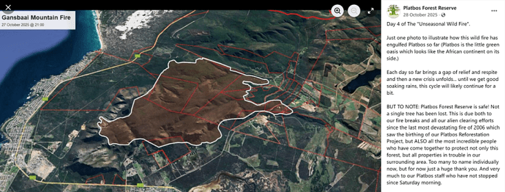
Above is a Facebook post by Platbos Forest Reserve (28 October 2025). The extent of the fire is outlined in white. The “oasis” (the indentation in the top right-hand corner of the demarcated perimeter of the fire) is Platbos Forest, clearly protected by its firebreaks. The built-up area along the coast is De Kelders, near Gansbaai. (Seehere)
🔥Bredasdorp Mountain Fire 7 November 2025
The next fire that preoccupied us was further away but nevertheless produced significant smoke across the region. This fire was reportedly maliciously started on 7 November 2025 in Bredasdorp near residential properties that were saved from the fire. Over the next few days, the fire ranged across the mountains to Napier, a distance of about 16 km (10 miles). Active firefighting to contain the fire and protect infrastructure and deal with flare-ups continued for over a week.
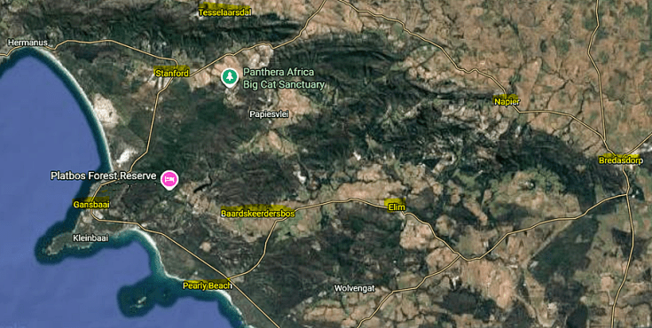
Map of the region highlighting some of the places where fires occurred in late 2025 and January 2026, including Stanford and Gansbaai, from Google Maps. (See here)
🔥De Kelders/Gansbaai Fire 23 November 2025
On 23 November another fire flared up near Gansbaai, this time at De Kelders. By the 25th November it was burning out of control, a situation complicated by a second fire at the Gansbaai township of Masakhane. Power was unavailable in some areas after electricity poles were burnt to the ground. It took a few days for conditions to allow for electricity to be restored. Once again, the main road between Stanford and Gansbaai saw several closures due to smoke and the fire jumping the main road, and once again Grootbos had to evacuate lodge guests as a precautionary measure.
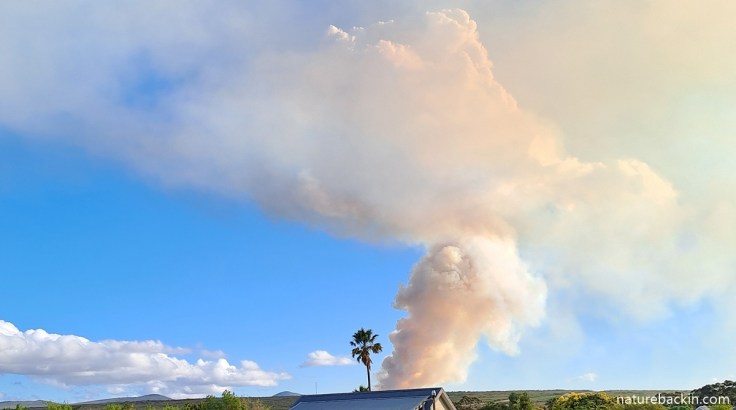
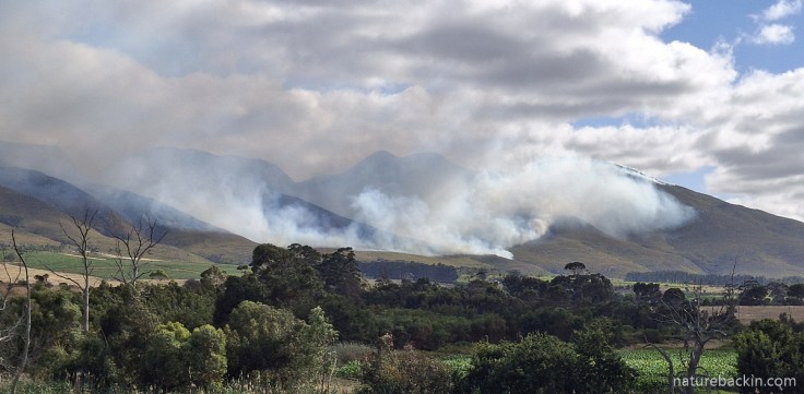
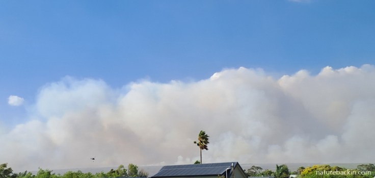
Smoke seen from one of our loft windows as the fire continued spreading from Gansbaai on 25 November 2025
Yet another fire, this one near Stanford, was extinguished on 29th November, but smouldering fires caused ongoing flare-ups in difficult-to-reach vegetation. The Overberg Municipality noted on 1st December 2025 that “firefighting activities included anchoring the fire line on a firebreak and guiding it around structures where required. This approach will remain the main objective for the week, with crews focusing on making use of existing and available firebreaks and using tracks to allow the fire to burn safely into. Aerial resources have been used to limit the spread of the fire.” At this stage one of the fire lines was spreading towards the informal settlement of De Kop near Stanford. This part of the fire was eventually contained and structures at De Kop were protected.
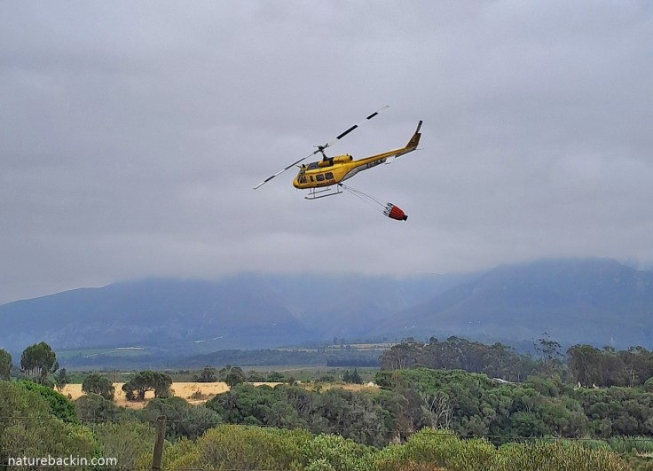
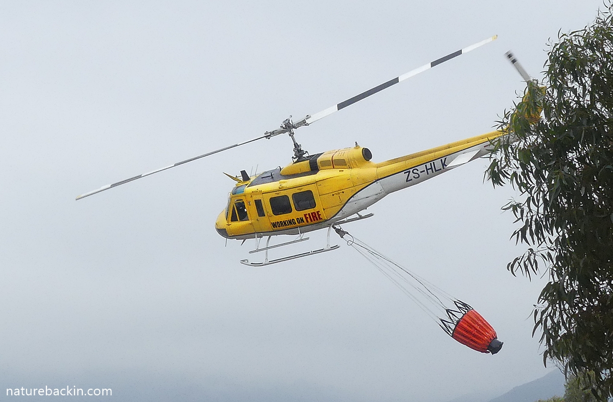
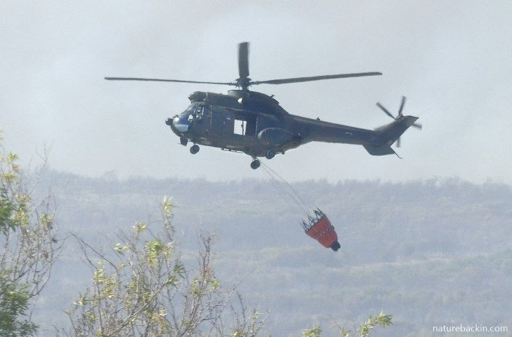
A Working on Fire Huey helicopter descending to the Klein River near our house, to fill the water bucket (up to 1200 litre [317 US gallons] capacity) suspended beneath it, on 28 November. On that afternoon, as on several other days, the helicopter flew relentlessly for about 2 hours back and forth from the river to the head of the fire, contributing to slowing the onslaught of the fire
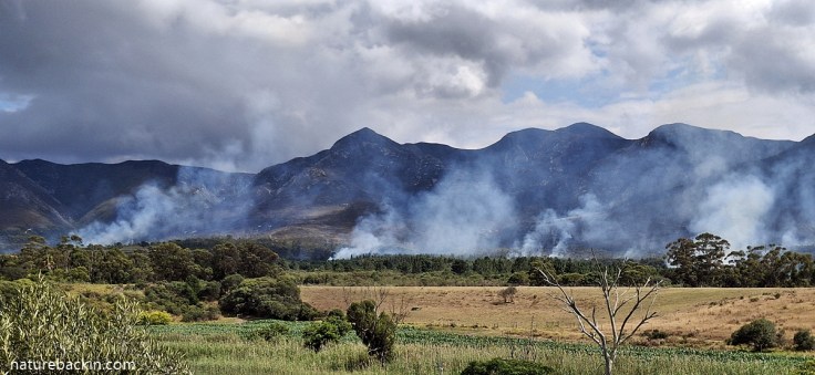
Smoke visible from our window from the still-burning De Kelders/Gansbaai Fire on 2 December 2025
The exhausted firefighters continued with their determined battle against the fire and numerous flare-ups. On 4th December the update reported that the “fire line has been driven by both the wind and the available fuel, spreading unpredictably as the wind shifted direction. Various control lines were established to contain the fire within a designated block. However, large unburned patches, or “islands,” remain within these lines and are likely to continue burning for weeks due to the mixed vegetation in the area”.
Landowners and firefighters “will keep monitoring the perimeter and carry out mop-up operations to ensure the area remains secure. Spot fires outside the control lines remain the most significant risk, and if these are not contained, they will create new fire lines. Landowners must stay vigilant.”
Indeed, on 6th December a significant flare-up took place in the Walker Bay Nature Reserve, requiring increased efforts from the firefighting crews in their ongoing management of the fire.
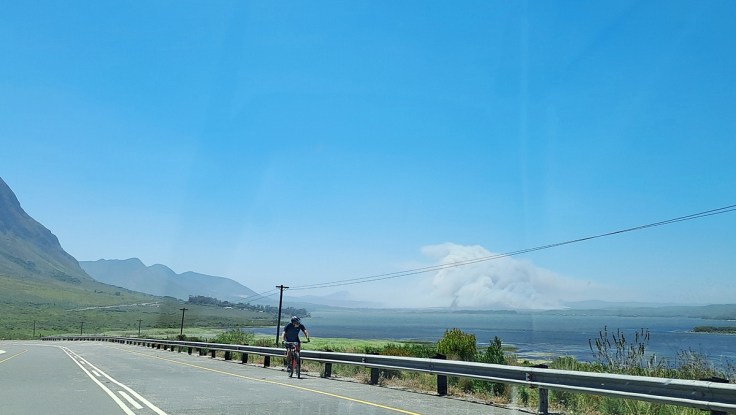
🔥Tesselaarsdal/Stanford fire 20 December 2025
You can imagine our dismay when we saw from a window distant smoke rising, this time to the north, over the nearby Klein River Mountains on 20th December. We learnt that there were two fires – one was a mountain fire near Tesselaarsdal that is approximately 10 km (6 miles) away on the other side of the mountains from Stanford, and the other was near the town of Caledon, just over 20 km (12 miles) away from Stanford as the crow flies.
Smoke over the Klein Rivier Mountains from the Tesselaarsdal fire on 20 December, seen from next to our house in Stanford
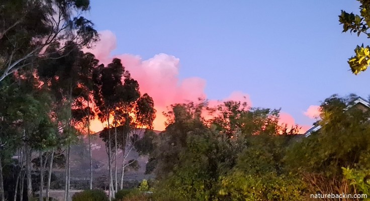
Later on in the evening the flames became visible along the tops of the mountains. This photo was taken from one of our loft windows
During the night there were several fire lines in the mountains. The one we could see progressed downhill towards farm properties just outside Stanford at the foot of the mountains. Firefighting that night and the next day focussed on protecting the structures and vineyards on those properties. By the next day this part of the fire was mostly contained. Efforts continued in preventing the fire spreading in the direction of Hermanus.
The fire was allowed to burn in this pocket of alien vegetation (that included eucalyptus and pine trees) as the perimeter was secure. The flames in the tall and flammable alien vegetation are clearly visible and are in contrast to the slower burn on the mountain slopes. The blackened mountains contrast with the green vineyards that were successfully protected from the fire
The relatively slow-burning mountain fire burning down the mountain slopes towards the vineyards and farmlands on 21 December 2025. Photo taken not far from our house in Stanford
Pockets of smoky fires still burning in alien vegetation at the base of the mountains on 23 December. These pockets were largely contained though still being monitored.
On 24th December there was the blessing of cooler weather and some drizzle that helped dampen down the heat. Pockets of fire in blocks of alien vegetation were allowed to burn out within a secure perimeter.
There was still smoke rising on Christmas Day. Firefighters remained vigilant in case of flare-ups but the active firefighting was largely done. The best Christmas present.
🔥Pearly Beach and Stanford fires 4 January 2026
On the 4th of January there was news of a new fire south-east of Gansbaai, at Pearly Beach that is about 23 km (15 miles) from Stanford as the crow flies. Firefighters were mobilised as the fire burnt on both sides of the main road between Pearly Beach and Gansbaai. The road had to be closed due to poor visibility in the smoke. Aerial resources were activated to assist the ground crews.
Over the next few days road closures and detours were in place. In hot and windy conditions, the fire continued to spread into thick coastal bush and also inland so fire fighting continued on these two flanks. There was heavy smoke. Motorists could leave Pearly Beach only under escort and when conditions allowed for this. Access to Gansbaai from Pearly Beach was closed so the only road out was via an inland detour. On 6th January residents at Pearly Beach and Eluxolweni were warned that evacuation might become necessary. The municipality reported that unfortunately some infrastructure was lost, affecting electricity and wifi infrastructure and some farm buildings.
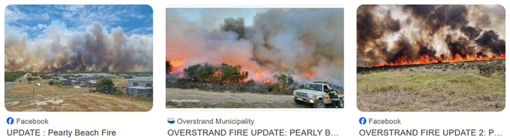
Thumbnails on Google images relating to the Pearly Beach fire in January 2026
On the morning of 7th January the road between Pearly Beach and Gansbaai was reopened. The municipality reported that approximately 200 people were actively involved in the firefighting operations, supported by aerial resources. The work was aimed at closing off blocks to contain the fires lines and any flare-ups. By the afternoon the fire lines in the mountains were burning inland towards Baardskeerdersbos.
And then in the evening there was the news of another fire near Stanford. While there was still enough light, aerial support was deployed in an effort to contain the fire.
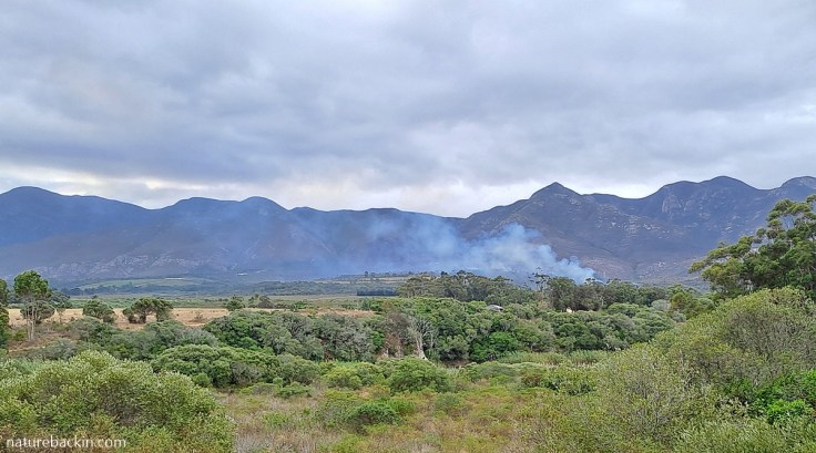
Driving back from Hermanus towards Stanford on the morning on 8th January, we were dismayed to see smoke rising in a column close to Stanford
On the 8th January conditions became increasingly grim and the status of the Stanford fire was escalated to a Code Red fire emergency. As the fire was out of control and posing an immediate threat to people and structures and local resources were at near capacity, fire fighters from neighbouring municipalities joined the many crews already engaged in fighting the fires. To make matters worse, a flare-up occurred in the Tesselaarsdal mountain fire that started on 20th December.
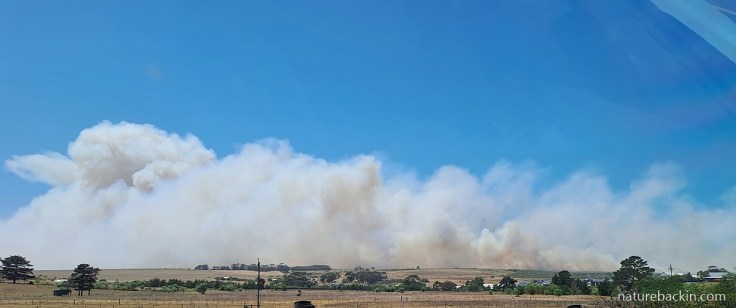
As we drove closer to Stanford, we saw the fire and smoke from the car window
Fanned by high winds, the Stanford fire was escalating out of control, with teams still active on the ground. Approximately 3 174 ha had burnt since the previous day.
The 11h00 update from the municipal manager noted the heavy smoke over the Stanford area with two active flanks of the fire burning fiercely. The left flank was heading towards Die Kop Informal Settlement, while the right flank was burning towards the R326 (the road from Stanford towards Riviersonderend). We were informed that “fire crews are on the scene, and it is all hands on deck. The Black Hawk helicopter is also currently engaged in aerial firefighting operations”. Residents were “urged to remain alert and be prepared for a possible evacuation should conditions worsen. Loud hailing is underway at Die Kop [informal settlement]. The Stanford Community Hall in Bezuidenhout Street is open for those who wish to evacuate their properties as a precautionary measure”.
Visitors/holidaymakers still in the area were advised to “consider starting to pack up, as current conditions indicate that the wind may carry the fire across the R43. The Stanford road may be closed this afternoon”.
Later that afternoon on the 8th January, the municipality update noted: “The fire has passed Panthera Africa and is burning in an easterly direction, fanned by high winds”. It was only later that we learned that in the strong and changeable winds, the fire approached with short notice at incredible speed and passed the sanctuary with devastating effects. See the box at the end of this post for more information about how Panthera Africa Big Cat Sanctuary was affected by the fire.
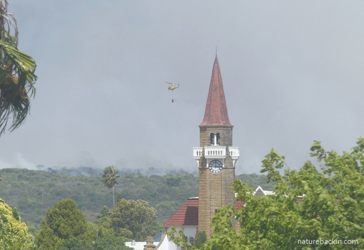
Taken from one of our loft windows on 8th January, the helicopter—visible to the left of the Stanford church steeple—carrying a full bucket of water to dump on the fire visible on the horizon. The helicopter flew back and forth repeatedly, filling its water bucket from the small dam in Stanford and then flying off to dump the water on the head of the fire
At the same time, sections of the Pearly Beach fire were also burning uncontrollably, including burning on the inland side. The municipal report noted the fire was burning “with high intensity across farmland and mountainous terrain and has spread in the direction of Elim”. Firefighters had to work hard to protect the town of Elim. Heavy smoke and windy conditions limited the use of the available helicopters.
High intensity fires were also burning on the coastal flanks. There was news that the fire had spread into the Agulhas National Park. Residential buildings were successfully protected at this stage. The report also noted that “from an estimated 1 600 ha (3 890 acres) yesterday, approximately 15 292 ha (37 790 acres) have burned since the fire was first reported on 4 January 2026”.
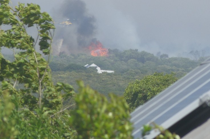
In the distance, beyond the tree being buffeted by the wind, and through dense smoke the helicopter can just be seen dumping its bucket-load of water onto flames that were approaching a farmhouse on the outskirts of Stanford. This photo was taken from our loft (pushing the zoom lens a bit far to capture this dramatic image). The farmhouse was saved
By the following day, 9th January, a further ±2 000 ha (±4 940 acres) were burnt in the Stanford fire that continued burning actively and out of control. With the fire fast approaching, residents at De Kop Informal Settlement were advised of a possible evacuation, and approximately 80 residents were evacuated to temporary shelter in the Stanford Community Hall. The fire was burning just across the main road from the Thembelihle residential area of Stanford amid heavy smoke. Amazingly, fire fighters with aerial support from helicopters managed to prevent the fire from burning structures at Die Kop and stop the fire from jumping the main road.
In the morning of 9th January, this photo was taken from our loft window. Residents were advised to be on standby to evacuate should conditions change
Meanwhile, fires continued to burn with high intensity at Pearly Beach, fanned by high winds causing three major flare-ups. Fire fighters had to cope with a change in the dynamics when the fire made a sudden 180-degree turn as the wind changed. Firefighting activities included working to contain the fire around the Pearly Beach Resort and teams managed to guide the fire around the residential area of Eluxolweni and residents were warned by SMS to remain alert as the area remained at risk.
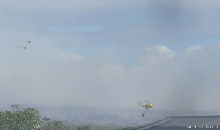
A view of two helicopters worked the same part of the fire as seen from our loft window. The one on the left with a full water-bucket is flying off in the direction of De Kop Informal Settlement. The one on the right has just returned to fill its water-bucket from the Willem Appel Dam in Stanford. This photo gives some idea of the smoke that one could not avoid breathing in as the smoke deposited fine layers of ash including indoors
On the morning of 10th January, a large army Oryx helicopter joined in the aerial water bombardment of the fire along the main road to Gansbaai and De Kelders, which was closed. The Oryx and the smaller Working on Fire helicopter were repeatedly filling their water buckets from the small Willem Appel Dam in Stanford. The unsettling sound of the beating of the helicopter blades had become an accompaniment to the fires that was simultaneously reassuring and unsettling in anxious times.
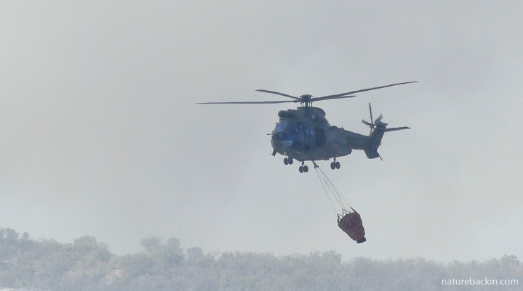
A large army Oryx helicopter joined the smaller Huey helicopters in fighting the fires. These photos were taken from our loft window as the helicopter descended to the Willem Appel dam to refill its water bucket
The ground crews continued day and night fighting the fires in strong winds and in hot conditions. Residents and local businesses stepped up with donations of food, refreshments and other supplies for the exhausted fire crews.
The smoke visible from our window on the morning of 10th January. The helicopters were already at work labouring to suppress the head of the fire
The municipal report noted that one might think there was nothing left to burn, and acknowledged the losses farmers, especially flower farmers, suffered in the fires.
Meanwhile in Pearly Beach where fire fighting continued day and night, most of the containment strategies were holding.
The pervasive smoke, seen from our window on 10th January 2026
The 11th January saw progress in containing both the Stanford and Pearly Beach fires. In the Stanford area renewed efforts were focusing on the inaccessible old vegetation (aliens and fynbos) where active fire lines were still persisting. In sections of Pearly Beach, firefighters and landowners remained on high alert for any signs of smoke or flames. The fuel load in dense alien vegetation, was conducive to flare-ups under strong wind conditions. The municipality reported that there was no immediate threat to houses and roads remained open.
On 12 January, in the early hours of the morning, the firefighters started a backburn of about 9 km in length to contain the Stanford fire in a defined block in which the fire could safely burn itself out. This backburn was the largest in the history of Overstrand Fire Services. Working together with local Fire Management Unit (FMU) members, the backburn was successfully completed after 19 hours of continuous work. A perimeter of around 10 km was established to prevent the fire from spreading further.
The weather cooled slightly and the wind eased, helping the firefighters with these efforts, but the risk of flare-ups remained high, especially in the areas invaded by rooikrans. In Pearly Beach fire crews continued with monitoring and mop-up operations and patrols.
Night view from our window on 12th January, looking more-or-less to the south-east
On the next day (13th Jan) efforts continued to contain the Stanford fire, made difficult due to the inaccessibility of unburnt areas that had a high fuel load with old, dry and dense vegetation that increased fire intensity. Landowners were assisting with creating access routes along the fire perimeters. Maximum firefighting resources continued to be deployed.
Parts of the fire at Pearly Beach flared up including in the mountains with an expected change in the wind adding to challenging conditions and the likelihood of further flare-ups. All roads remained open.
The nightmare continued, and on 14 January 2026, due to flare-ups both fires were out of control again. In the Stanford fire, two Huey helicopters were active, with the Oryx helicopter deployed to a flare-up in Pearly Beach.
Miraculously, late that evening drizzle arrived to dampen down out-of-control fire that was raging towards Baardskeerdersbos and Elim. Without the rain it could have been disastrous.
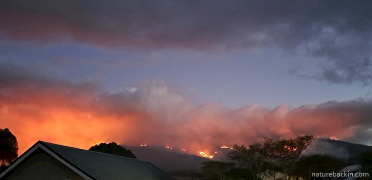
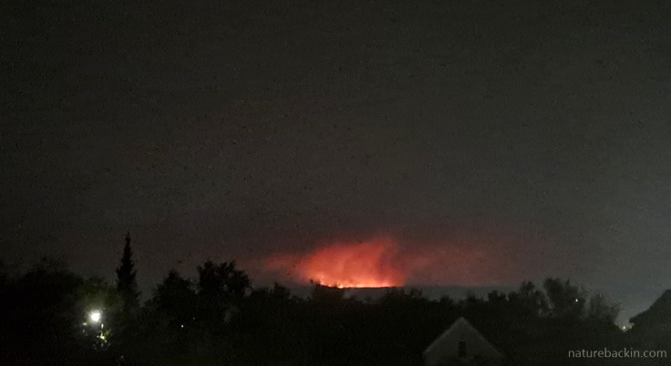
The fire in the direction of Elim and Baardskeerdersbos from our window on 14th January, just before the drizzle that dampened down the flames
The update from the municipality the next day (15 January) was that although the rain brought much needed relief and that the cooler weather would assist the firefighters “we are not out of the woods yet”.
The work of the fire fighters continued, and fresh teams were brought in from neighbouring areas to assist. Further backburns were needed in a section of the Stanford fire, and further firelines still needed securing. At Pearly Beach, activities even included cutting through dense rooikrans with chainsaws. And more generally mopping-up activities continued. This work is far more exhausting than the phrase “mopping-up” even begins to convey.
Even while the fires were raging, the municipality engaged a Enviro Wildfire Consultancy to investigate the causes of the Pearly Beach and Stanford fires. The outcome of the investigations is yet to be reported.
I have tried to give an impression of the relentlessness of these fires, but there are many aspects and also several smaller fires that required attention that I have not had the knowledge or the space to mention. There are many traumatic experiences and losses that a summary such as this cannot cover.
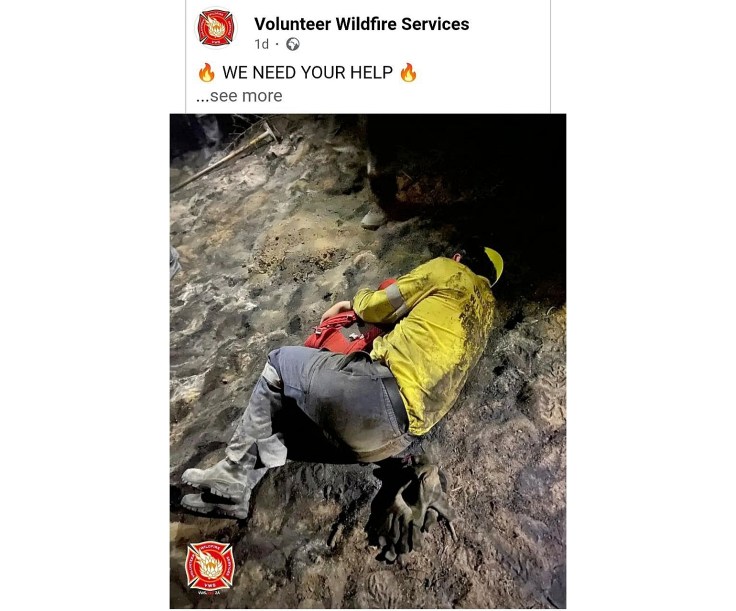
This image of a bone-weary volunteer firefighter resting while out in the field in the Pearly Beach fire in January 2026 perhaps conveys something of what the firefighters went through. As individuals and as a community, we cannot sufficiently convey our gratitude and appreciation of what the firefighters accomplished under challenging, often terrifying and exhausting conditions. (For more info and source of this photo see here)
Extensive damage by a wildfire to Panthera Africa Big Cat Sanctuary January 2026
Panthera Africa Big Cat Sanctuary is a non-profit, ethical big cat sanctuary. All their big cats have been rescued from unsuitable and abusive condition. In addition, Panthera Africa works to expose the cruelty of the captive lion industry and raise awareness for captive big cats. For short biographies of the individual animals cared for at Panthera Africa see https://pantheraafrica.com/the-pride/
The Sanctuary is in desperate need of ongoing financial support to help cover the costs of transporting the animals to safety and their veterinary care, and fighting the fire and repairing the infrastructure. They also need to fund the sanctuary’s normal operational costs. With the sanctuary closed they have lost their primary sources of income. To donate see https://pantheraafrica.com/wildfires/
On 8th January 2026, Panthera staff received a warning that an uncontrolled wildfire was racing towards them. They were told that they had two hours before the fire reached them, but that quickly became one. Panthera requested aerial support from helicopters as staff began crating animals for evacuation, with a vet on the way to assist. The stressfulness of this emergency cannot be overestimated.
With remarkable cooperation and partnering from other big cat sanctuaries across the country, Panthera’s larger animals have been temporarily relocated for safety and care while Panthera recovers from the fire.
However, it later became apparent that two of Panthera’s cats, Arabella, a tigress, and Baguira, a lioness, sustained burns that required intensive veterinary care and ongoing treatment.
The fire destroyed several big cat camps and critical infrastructure, including electrical and perimeter fencing and multiple animal enclosures. The accommodation and other buildings were saved. Initially, Panthera reported on Facebook: “Thanks to the courage and dedication of our team, all 26 of our animals were kept safe, with those in immediate danger successfully moved out of harm’s way. The majority of our animals escaped without critical injuries”.
Tragically, one of Panthera’s tigers died as a result of smoke inhalation. “Despite every effort and having been moved to safety in time, our beloved tiger, Rays, did not survive. Smoke inhalation combined with the darting led to lung oedema and cardio-respiratory compromise. He fell into a coma and passed away peacefully on Saturday, 10 January. His loss has been deeply felt by our entire team and the local community. There are no words to capture the depth of our grief”
Panthera provided some good news on 12 February 2026, that Baguira had recovered enough to leave intensive care and has been cleared to return home. For details see https://Help us bring Baguira home. Before being rescued and gaining sanctuary at Panthera, Baguira was a circus lion in Argentina where she had lived for six years confined to a small trailer. Meanwhile, Arabella, the tigress, continues with her intensive care.

Sources:
Greater Overberg Fire Protection Association. [n.d.] Get involved: Here’s how you can help. https://overbergfpa.co.za/get-involved-heres-how-you-can-help/
Overstrand Municipality. Daily fire updates from Overstrand Municipality. https://www.facebook.com/overstrandmunicipality?ref=embed_page
Panthera Africa Big Cat Sanctury. January 2026. Wildfires at Panthera Africa. We Urgently Need Your Support. https://pantheraafrica.com/wildfires/
Western Cape Government. Department of the Premier. 22 January 2026. Premier Winde and Minister Bredell provide update on water security challenges and wildfires. https://www.westerncape.gov.za/department-premier/article/premier-winde-and-minister-bredell-provide-update-water-security-challenges-and-wildfires
Posted by Carol

Discover more from letting nature back in
Subscribe to get the latest posts sent to your email.


February 27, 2026 at 2:29 pm
Dear Carol, my heart goes out to you and your community. The raging fires are so terrifying and relentless, but the firefighting efforts are astounding. I hope the rains you wrote of at the beginning have extinguished some of the danger for now. Stay safe, my friend.
LikeLiked by 1 person
February 28, 2026 at 12:40 pm
Hi Jet. Thanks so much. There have been no fires since the rain. Already the resprouters in the fynbos and some of the bulbs are showing signs of life. The reseeders should start springing up once the winter rains and cooler temperatures arrive.
We are getting an autumn feeling on some days already. Perhaps you are already sensing spring is on the way before too long? You must be looking forward to the longer days.
LikeLiked by 1 person
February 28, 2026 at 11:13 pm
Hi Carol. Yes, spring is on the way here in northern Calif. Daffodils in bloom and blossoming fruit trees. But the winter birds are still in our backyard, which to me is wonderful. I hope your winter rains and cooler temperatures promise to bring more relief. Sending warm wishes….
LikeLiked by 1 person
March 1, 2026 at 3:17 pm
Hi Jet – well the daffodils and fruit tree blossoms are excellent heralds of spring, even while the winter birds are still present.
Thanks for your good wishes for our rainy season. After moving here from a summer rainfall region it is a whole new experience for me to look forward to winter!
LikeLike
February 22, 2026 at 11:06 am
A sobering, terrifying post. Your documentation is admirable. Thank you Carol
LikeLiked by 1 person
February 16, 2026 at 1:40 pm
Such a vivid account, Carol. Regretfully, reports of wildfires around the globe reach my newsfeeds far too often but you have captured the relentlessness of the tasks faced by the heroic firefighters and the fear that those of you in the area must have experienced. Difficult to read and undoubtedly more difficult still to write. Thank you
LikeLiked by 1 person
February 18, 2026 at 2:08 pm
Hi Sandra. Indeed, we read of disastrous fires and floods and other extreme weather events around the world continually. When it happens closer to home, at times it can sometimes seem to be happening in a parallel universe, slightly unreal, but I guess that is just a coping mechanism, and probably not possible when one is actually in the path of a fire hurtling fearsomely towards one.
I hope you have escaped any extreme weather events in your area this winter?
LikeLiked by 1 person
February 19, 2026 at 9:59 am
Such things are very rare in our corner of the country, Carol. Cornwall is a peninsula and with sea on three sides, the climate is mild. And wet!
LikeLiked by 1 person
February 16, 2026 at 9:25 am
How terrifying. The more so because this is something I guess you will have to live with, year after year afer year. And yet again, human interference with the land in ways that the territory cannot easily accommodate seems to have made a bad situation worse. Presumably plans are afoot to modify land use in the new situation? How devastating for so many of your not-so-distant neighbours who must have lost everything. Thanks for this report, which can’t have been easy for you to put together.
LikeLiked by 1 person
February 16, 2026 at 11:55 am
Hi Margaret – indeed yes, the prospects going forward are bleak, as for most of the planet (when one has the strength of mind to think about it). There have been plans and initiatives for the control/eradication of invasive alien plants for many years. As far as I can make out, successes have been spotty and the scale of the problem is huge. In the wake of the recent fires there is increased lobbying to do more effective work – it is expensive, but even a fraction of what it costs to fight the fires would go a long way. Lets hope at least some new initiatives and projects come together effectively.
Yes, there is devastation as the land has been turned to dust. And for example, fodder for animals is burnt up, farm water pipes got melted, fence posts were scorched or burnt down, bee hives were destroyed (although some were heroically saved), and the toll on wildlife, tortoises for example, has been heavy.
Yes, I did find it quite confronting putting this report together.
We have had some heavy rain, too heavy actually, but it will help plants regenerate. But today its back up to 38 degrees, We just have to try to roll with it I guess.
Sending best wishes
LikeLike
February 16, 2026 at 9:19 am
Carol, your text and photos capture this devastating time so incredibly well and conveys the horror of it for people like you in the thick of it in Stanford. The firefighters are indeed worthy of the highest praise. So much more could have been lost.
LikeLiked by 1 person
February 16, 2026 at 11:45 am
Hi Christine. Thank you – I was not sure how to approach this extended period of fire, but hoped that a local record and a degree of detail might make the experience more relatable than a newspaper article. I so agree with what you say about the firefighters. Their achievements were extraordinary.
LikeLike
February 16, 2026 at 6:58 am
There is no easy way to view an out-of-control wildfire. That some are deliberately started is horrific to even think about – but they are. The tinder-dry conditions here in the Eastern Cape have already led to terrible fires and we still have had no rain of any significance. The headline in today’s newspaper highlights the fact that our town has now been without a reliable water supply for six weeks. Your reportage of the fires in your region is excellent – as are your dramatic photographs – and boil down to two things immediately in my mind. The first is the proliferation of alien vegetation (whatever happened to the Working for Water campaign?) and the second is how underrated our firefighters are. They need all the support they can get.
LikeLiked by 1 person
February 16, 2026 at 11:42 am
Hi Anne
The long-term implications of water infrastructure problems in the country boggle the mind, and they are frightening. The immediate problems are also horrifying and it is incredible that your town has been without water for six weeks, but your lack of reliable water in the taps has actually been going of for years, with no viable plan in sight, or so I gather? Add to that the dry and hot conditions leading to fires, some of which in the Eastern Cape have already been horribly damaging this season. When prospects of rain are also not good the situation is incredible bleak and worrying.
Then add the proliferation of alien vegetation and the apparent lack of resources and political will to address that.
I have been trying to find out more about how Working for Water is functioning, but it is quite difficult to find current information.
I also think our firefighters are underrated. What they achieved during the multiple fires, working in horrible conditions, was outstanding and heroic.
I do hope the dry areas of the Eastern Cape gets rain soon.
We had an extraordinary amount of rain last week due to a cut-off low. But it is back up to 37 degrees today.
Sending best wishes
LikeLike
February 16, 2026 at 2:49 pm
Our respite from the heat is over and we too are back to the thirties. Keep safe!
LikeLiked by 1 person
February 18, 2026 at 1:56 pm
Thanks. February is usually the worst of it, so lets hope March brings some rain and relief from the heat.
LikeLike
February 16, 2026 at 6:52 am
Wow, this just sounds like a never-ending nightmare, and such a harrowing experience to see so much of these fires from your home. It seems like there are so many more wildfires than there used to be, everywhere. I hope you continue to be safe and get to breathe some clean, smoke-free air soon. Take care.
LikeLiked by 1 person
February 16, 2026 at 10:24 am
Hi Graham and thanks for your good wishes. Amazingly, last week we had good unseasonal rains that should have extinguished any remaining smouldering, but at the price of some communities being flooded. But such extremes seem to be increasingly common – and everywhere, as you say.
I hope that your area is relatively extreme-free, even taking volcanos into account!
LikeLiked by 1 person
February 17, 2026 at 6:11 am
Well the volcano does its thing, but even that is mostly well-mannered currently! We have not had a big issue with fires this past year even though it’s been very dry. Some flooding, but nothing out of the ordinary. Currently the world seems to be lurching from one disaster to another. Very depressing.
LikeLiked by 1 person
February 18, 2026 at 2:02 pm
It truly is depressing. Glad to hear though that your neck of the woods has mostly not had big or unusual issues to deal with. Long may that continue.
LikeLiked by 1 person
February 15, 2026 at 11:06 pm
What a harrowing experience for all involved. It was hard enough to read this post, I cannot imagine living it. I’m glad you are safe and avoided lasting damage, and my heart goes out to those who weren’t so fortunate.
LikeLiked by 1 person
February 16, 2026 at 6:52 am
Hi Eliza – harrowing is the word for those fighting to protect homes and livelihoods. The changeable and blustery winds added a degree of unpredictability to make matters even more challenging. We owe a lot to all those people who fought the fires day and night.
The world over people are being confronted with such extreme weather-related events.
Your area has had a very icy time that must have been challenging to say the least.
LikeLike
February 16, 2026 at 3:00 pm
Thankfully, the worst is behind us, onward to spring!
LikeLiked by 1 person
February 15, 2026 at 9:53 pm
Oh Carol, what an awful time you have had and continue to have! My thoughts are with you. It must be so unsettling and frightening to wonder where you will see the smoke next. Firefighters are so brave and work so tirelessly. I hope they will be rewarded!
I’m glad that most animals at the Big Cat Sanctuary were saved. Something to feel grateful for…
Stay safe and wishing you the best as you recover. Keep us updated when you can.
Best
Julie
LikeLiked by 1 person
February 16, 2026 at 6:43 am
Thanks very much Julie. It has been quite a fire season. So much turned to dust.
Now after the heavy rains green shoots are increasingly apparent but temperatures are back to harsh highs in mid 30s Celsius thus week.
I gather that a lot of North America has had to deal with very challenging winter storms. I expect you are looking forward to longer and warmer days?
LikeLike
February 17, 2026 at 12:25 am
Yes, we had a snowstorm with 25 inches of snow here, and a long spell of very cold weather. I’m really ready for spring.
-Julie
LikeLiked by 1 person
February 18, 2026 at 1:58 pm
I saw your lovely snow photos but didn’t realise it was 25 inches! That is a lot of snow (and a lot of melt, I imagine).
LikeLike
February 20, 2026 at 2:32 am
Yup,a couple more inches on the way tomorrow!
LikeLike
February 20, 2026 at 5:40 am
Ooh good luck with that 🧣🧤
LikeLiked by 1 person