
The Richtersveld is a reminder of vastness out there while the pandemic constrains us. Our (cancelled) three-week trip to three nature parks would have started in mid-May, so instead of actually going away, while under continuing lockdown I reminisce about a previous trip out into nature.
Of the many places we have been to, I am not sure why I chose to “revisit” the Richtersveld in this post. Perhaps its rugged remoteness and its ancient and elemental landscapes offer a reprieve from the smallness of current horizons?
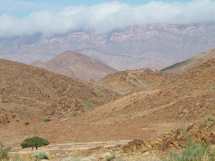
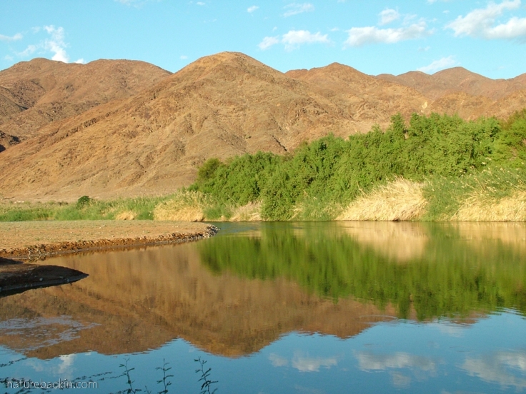
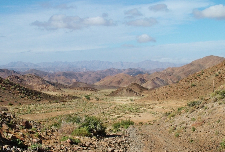
The landscape is full of drama – mountain ranges, hills, valleys, fascinating extrusions of rock, sandy dry river beds, plains and plateaus resembling moonscapes, and yet a river runs through it. Not just any river, but the Gariep (Orange) River.
The Gariep River rises in the mountains of Lesotho and runs west towards the Atlantic Ocean, fed by many tributaries as it flows. The river, with a total length of 2,200 km (1,400 miles), flows through the Gariep Dam, the largest dam in South Africa, and is used for irrigation, hydro-electric power, and much of its water is channelled to water-scarce regions of the country. Moving west the river runs through the arid regions of the southern Kalahari region and through Namaqualand, forming the border between South Africa and Namibia. In its final stretches before running into the Atlantic Ocean at Oranjemund, it bears alluvial diamonds, which are still mined including in the Richtersveld and also offshore along the coast.
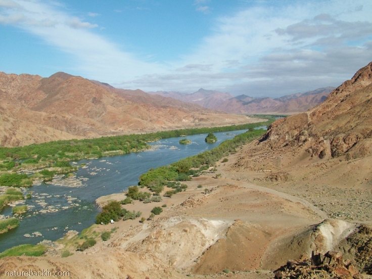
The Gariep River flowing through the Richtersveld National Park. It is the only perennial river in the region and it supports a diversity of life, including water birds

This photo is taken from the same spot as the previous photo with a view downstream. The De Hoop camping area is on the near bank of the river. The dot at the near small bay-like curve in the river is our campsite. Also visible are water tanks feeding the small buildings that house showers and toilets for campers
My husband climbed up above the camp to take the two previous photos. When he turned around with his back to the river this was the contrasting view
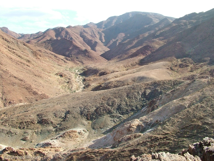
The Richtersveld National Park is in a region of extremes. The aridity contrasts with the permanent water flows of the river, the temperatures soar to the high 40s in summer and drop in winter to very low lows, typical of desert climates. Superficially, it looks desolate – a home of rock and sand, but it is a biodiversity hotspot.
The region falls in a transition between winter rainfall and summer rainfall zones. In a narrow zone, the plants of the (low) winter-rainfall Namaqualand region, part of the Succulent Karoo biome, and of the summer-rainfall Nama-Karoo biome mingle. To add to the complexity, the seaward facing slopes may get precipitation from heavy and regular coastal fog especially in the months of autumn, whereas the inland facing slopes are drier. The mountain ranges also have an effect on rainfall patterns and effectively create micro-climates. The section along the Gariep River bordering Namibia falls into the Desert Biome where conditions are harsher with even less rainfall.

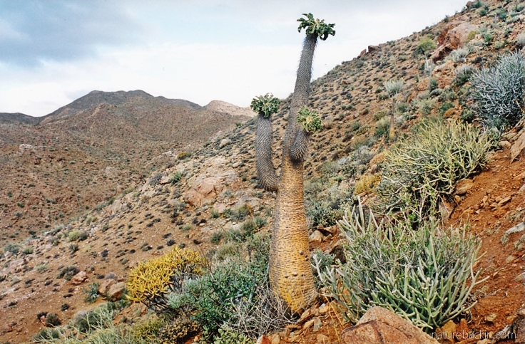
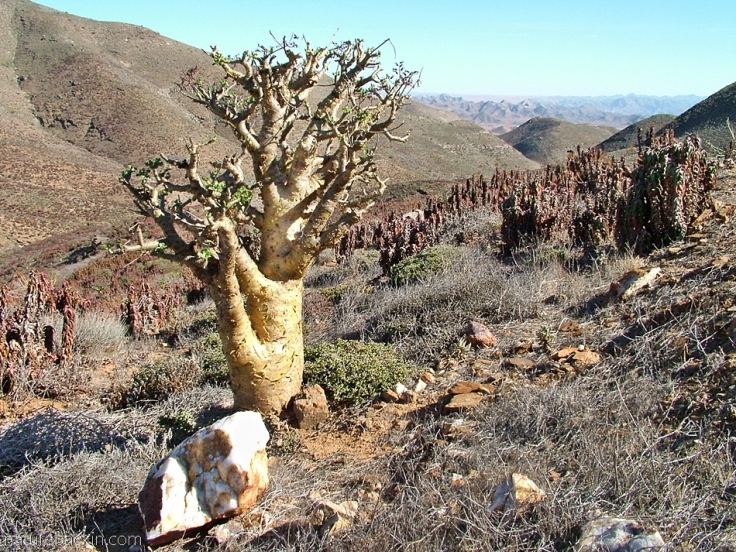
A view of a sandy plain dominated by a tall tree aloe, Aloidendron pillansii (formerly Aloe pillansii), an endangered species endemic to the region and a flagship species of the Richtersveld National Park. Its common names include giant quiver tree, bastard quiver tree and baster-kokerboom. Threats to its survival include “its small population size, low natural recruitment, illegal collecting, and habitat loss through mining, impact of livestock and climate change” (http://southafrica.co.za/plants-richtersveld.html)
The Succulent Karoo biome is exceptional in its biodiversity and it has the most succulent vegetation of any of the arid regions of the world. In the Greater Richtersveld region there are about 2700 species of plant, with 80% being succulent. Endemic plant species number 560 with 194 of the plant species being classed as Red Data species.
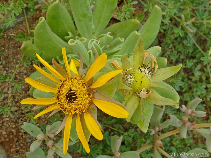
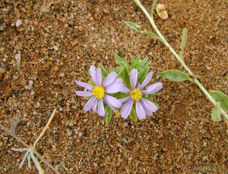
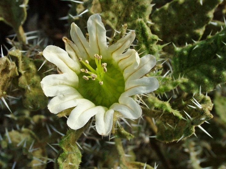
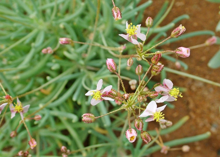
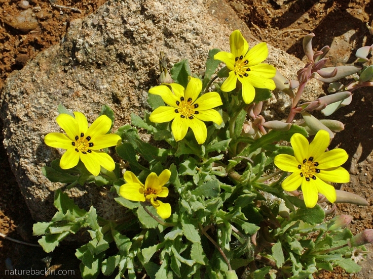
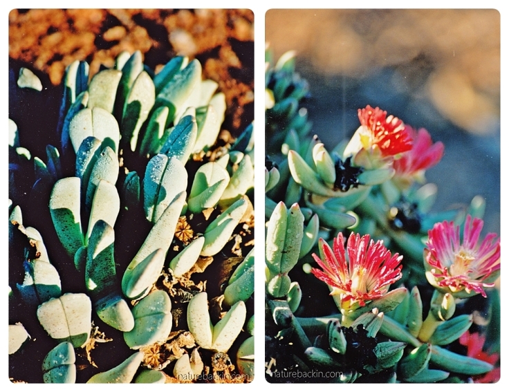
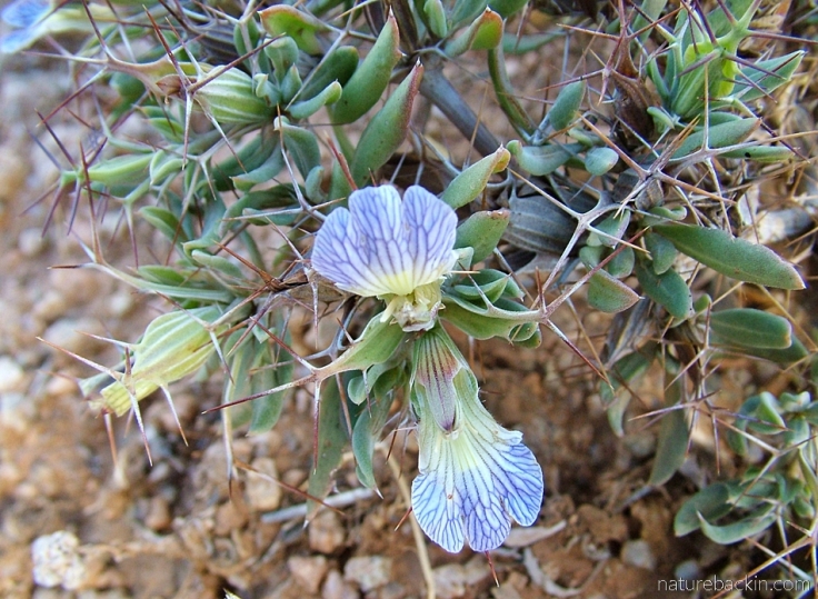
The region is famous for its massed spring flowerings of colourful flowers. However, even in May (early winter) flowers may still be found. The following photos are of some of the flowers we saw during our visit to the Richtersveld in May 2008.
One of the more renowned plants of the region is the Halfmens (Pachypodium namaquanum) – a succulent plant endemic to the region that can be several metres tall. It drops its leaves to conserve moisture in the summer and its growth takes place during the winter. It inclines its rosettes of leaves towards the sun to maximise its benefit and to expose its flowers to pollinators. In a group all the plants can be seen inclining towards the north. Legend has it that people who had been driven off their land turned to look back longingly at their homeland, and the gods took pity on them and turned them into half-men half-plants able to look back forever at their homeland (http://pza.sanbi.org/pachypodium-namaquanum).
A halfmens plant tilting slightly to the north. This is photo is scanned from a print I took on our first visit to the Richtersveld in the winter of 2002

View of distant mountains and in the foreground the smaller of the tree aloes, the maiden’s quiver tree (Aloidendron ramosissimum) and two botterbooms (Tylecodon paniculatus). The botterboom is another summer deciduous species. Like the halfmens it grows its leaves during the winter months. During summer it photosynthesises through its yellowish-greenish stems (http://pza.sanbi.org/tylecodon-paniculatus)

The beautiful yellow flowers of the maiden’s quiver tree. Reputed to flower from June, we were perhaps fortunate to see them already flowering in early May during our visit in 2008
One of the loveliest places to camp in the Richtersveld National Park is at the De Hoop camp on the bank of the Gariep River. Visitors to the park have to carry with them the water they need, but here one has a supply of fresh water straight from the river. When we first visited in 2002 there were no showers or toilet facilities at all. But by 2008 a small building, housing toilets and cold-water showers was a welcome addition.

A view upstream and our campsite can be seen in the distance on the right-hand side. What a beautiful place to camp and watch the light change on the water and on the mountains
The view from our campsite across the river in the afternoon sunshine. In 2008 my husband and I traveled alone and we enjoyed the simple solitude

However we were visited by birds such as this pair of African red-eyed bulbuls watching us in our camp

Other birds visiting our camp included this Orange River white-eye
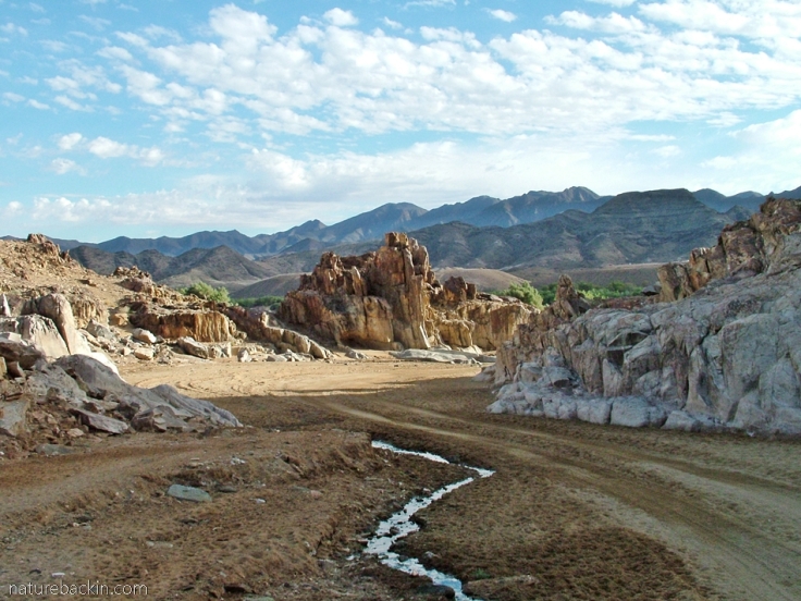
The road to Potjiespram, one of the other campsites in the park
The Richtersveld National Park was proclaimed in 1991. The land is leased to the South African National Parks Board by the local Nama community and it is managed jointly by SANParks and the Nama community. Nomadic Nama stock farmers continue to graze their livestock on the land.
To the south of the park is the Richtersveld Community Conservancy, which in 2007 was proclaimed a UNESCO World Heritage Site in recognition of the importance of the transhumance lifestyle of the Nama stock farmers who migrate seasonally with their livestock and of the need for the protection of the botanical diversity of the region (https://whc.unesco.org/en/list/1265/). Unlike in the Richtersveld National Park, there is no diamond mining in the Heritage Site.
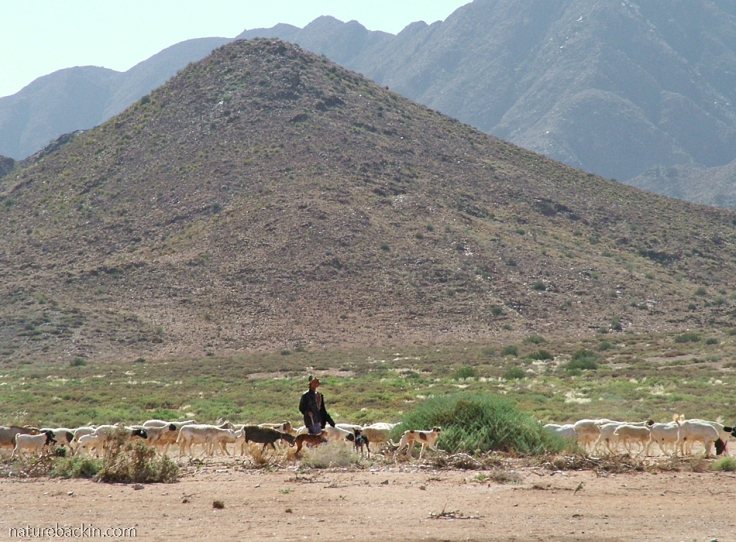
In the far distance we saw a herder walking with his goats, sheep and dogs in the Richtersveld National Park
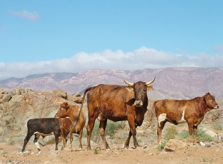
In another section of the park we saw a herd of hardy cattle wandering freely
In 2003 the ǀAi-ǀAis-Richtersveld Transfrontier Park was formalised between the RIchtersveld National Park on the South African side of the Gariep River and the ǀAi-ǀAis Hot Springs Game Park in Namibia. The Fish River Canyon, the largest canyon in Africa, is located in the park.

Map from: https://www.richtersveldnationalpark.com/map.html The Richtersveld National Park is located 875 km north of Cape Town
This is my version of an iconic and most photographed view in the Richtersveld National Park

A quiver tree, a botterboom and I – bearing witness to the great yonder
And one of the final views at Helskloof pass as we were leaving the park. A quartz rock, a botterboom and a colony of red-leaved Aloe peasonii drawing the eye to yet another range of mountains in the distance
Currently, because of the Covid-19 pandemic all national parks are closed to the public. For more information from SANParks about the Ai-ǀAis-Richtersveld Transfrontier Park see https://www.sanparks.org/parks/richtersveld/
Posted by Carol


May 29, 2020 at 7:47 pm
Just stunning! I hope that we are all able to travel again eventually. I was supposed to be in Armenia in May but of course, that didn’t happen.
LikeLiked by 1 person
May 29, 2020 at 8:03 pm
Thanks Adele. I am sorry that you are missing your planned time in Armenia. It is likely to be awhile before travel resumes and even when it does much will be altered. I try to live more day to day without expectations that may turn out to be unrealistic, but it can be difficult to shut down on thinking too much about the future as we are so used to planning ahead. These are sad and testing times.
Take care and keep safe.
LikeLiked by 1 person
May 29, 2020 at 8:24 pm
Thank you Carol. Take care too.
LikeLiked by 1 person
May 26, 2020 at 11:57 am
Wow a beautiful post! Love the ‘moonscape like’ topography of the landscape. Definitely on my bucket list. Amazing how one would think it to be quite barren and yet it is teeming with diversity as you describe. What interesting plants – love the tree Aloes.
LikeLiked by 1 person
May 26, 2020 at 3:08 pm
Thanks Carol. It is the most astonishing place. I hope you get to visit there one day – it will yield much for your painterly eye!
LikeLiked by 1 person
May 26, 2020 at 11:12 am
Thank you for such an interesting journey with wonderful photographs from your past trips there.
LikeLiked by 1 person
May 26, 2020 at 1:37 pm
Thanks Christine – I enjoyed revisiting it too and it made me realise I still have a lot to learn about it – for instance, the geology is incredibly complex and I need to try to read more about it. I gather that the Cape Fold Mountains are linked to geological activity and sediments from the region – most intriguing!
LikeLike
May 26, 2020 at 9:09 am
A spectacular landscape, Carol; thank you for this virtual trip. I have also read of animals changing their habits whilst the parks are closed. Astonishing how quickly they began to change. But I also share your concerns at the loss of income. And I wonder too whether there will be an increase in illegal hunting?
LikeLiked by 1 person
May 26, 2020 at 1:32 pm
Thanks Sandra. It is surprising how quickly the animals are adapting. Sadly I have heard that there is an increase in trapping in some nature reserves – many people neighbouring such places live in poverty that has been intensified by the economic and social consequences of the pandemic. Very complex and difficult times these are.
However, I hope that you keep safe and well. On this overcast and wintry day here I am imagining the spring-into-summer landscapes and gardens in your part of the world.
LikeLiked by 1 person
May 26, 2020 at 1:48 pm
Yes, I feared that poverty and need might by driving factors. It is, as you say, such a complex situation. We are well here and have the luxury of a glorious spring. A long stretch of dry weather with many warm days, especially at the moment. It’s good to be outside here right now 🙂
LikeLiked by 1 person
May 26, 2020 at 5:04 pm
Good to hear about your lovely spring weather,
LikeLiked by 1 person
May 26, 2020 at 3:07 am
I have never been to your country. I enjoy your stories and photos of the grandest views and the smallest of beautiful plants and creatures. I especially liked the legend of the Halfmens tree. I, too, miss adventuring to rivers, mountains, forests, fields, and wetlands here in the Pacific Northwest U.S. May we stay well and healthy and visit familiar places and new ones, in good time.
LikeLiked by 1 person
May 26, 2020 at 1:26 pm
Its good to know that those wild or at least more natural places are still out there, and now it is important to be sensible and protect others and ourselves the best ways we can. We are fine thanks, and as today is the coldest day so far of the season and we are using our wood burner for the first time this season. The cats and dogs and very happy about that 😊 You and Dixie take care too,
LikeLiked by 1 person
May 26, 2020 at 2:04 pm
You are cooling down as we are warming up. Earth is a wonder.
LikeLiked by 1 person
May 23, 2020 at 4:54 am
I bet you can’t wait to get back into the great outdoors. What wonderful wide open spaces these are. They can look barren but are often teeming with wildlife and other things of interest. The halfmens are fascinating and other-worldly.
LikeLiked by 1 person
May 23, 2020 at 4:20 pm
It is an other-worldly place in many ways. Yes it will be good to get out and about whenever that might be, but as you know I find lots of interest in the garden so will have to be content at a more micro-level …
LikeLiked by 1 person
May 24, 2020 at 6:47 am
The micro-level is great too. Nothing like staring at bugs to pass an hour or two.
LikeLiked by 1 person
May 22, 2020 at 5:55 pm
We were there in September and the water was cold
LikeLiked by 1 person
May 22, 2020 at 5:59 pm
I can imagine it was! You are braver than I am 🙂
LikeLiked by 1 person
May 22, 2020 at 1:19 pm
Sorry you had to cancel your trips. We can’t even get out to the Walter Sisulu Botanical Gardens which is one of our favourite ‘day’s outing’ over a weekend. We live in Johannesburg. Sadly lockdown has put so many simple pleasures on hold. Beautiful pictures, thank you.
LikeLiked by 1 person
May 22, 2020 at 5:53 pm
Thanks Amanda. It is a shame that outings in the parks and gardens are not possible now. Walking in city and suburban streets is not the best.
Take care in these uncertain times.
LikeLike
May 22, 2020 at 5:57 pm
Thank you, and you too
LikeLiked by 1 person
May 22, 2020 at 9:31 am
Oh Carol, you have stirred memories of a trip we did to the Richtersveld ten years ago and a longing to return. At the risk of being boring I have to tell you that a swim in the Gariep at the De Hoop camp was the best I have ever had. We also camped at Kokerboomkloof and that enchanting and eerie.
LikeLiked by 1 person
May 22, 2020 at 5:47 pm
Glad to hear that you have visited there too. We did not make it to Kokerboomkloof – it sounds to be incredible. I did not summon up the courage to swim in the river as it was extremely cold the first time we visited (in June) and very cold on our second visit (in May). My husband swam in the river and it was bracing to say the least but definitely memorable!
LikeLiked by 1 person
May 22, 2020 at 7:52 am
This has been a wonderful virtual trip to an area that has long been on our bucket list for when …
LikeLiked by 1 person
May 22, 2020 at 5:44 pm
I hope that when that when eventuates you will be able to make plans to visit this fabulous region.
Take care in these times.
LikeLike
May 22, 2020 at 6:27 am
Very special memories, thank you for sharing Carol! xxx
LikeLiked by 1 person
May 22, 2020 at 5:43 pm
Thank you Christeen – yes it was interesting to revisit these memories in some detail. I hope you are all set for the colder weather forecast for next week!
LikeLiked by 1 person
May 28, 2020 at 9:51 am
Carol we’ve been enjoying cosy fires each evening, though grateful that the weather wasn’t as extreme as forecast! 😉 xxx
LikeLiked by 1 person
May 28, 2020 at 8:23 pm
Lovely to have a cosy fire – it has been cold enough even here for us to light our woodburner the past three evenings. It seems to be colder than this time last year …
LikeLiked by 1 person
June 1, 2020 at 3:56 am
Definitely a bit cooler this May, 5C min and 25C max last year, this year 0C and 21… xxxx
LikeLiked by 1 person
June 1, 2020 at 7:15 pm
Thanks Christeen that is interesting – useful to keep records!
LikeLiked by 1 person
May 22, 2020 at 5:22 am
This is a wonderful post, Carol. It’s completely unlike any landscape I’ve experienced anywhere – I’m not well travelled outside Europe – and the plant life you describe is astonishing. I’m so sorry about your cancelled trip – let’s hope that the National Parks will be able to re-open soon, though they may be relishing the break from humankind. Not that you two provide any kind of threat!
LikeLiked by 1 person
May 22, 2020 at 5:42 pm
Thanks Margaret – it is a place with landscapes that are unique. The exceptional diversity of plant life in the arid landscape is indeed astonishing.
At this stage it is unlikely the National Parks will open for some time. I have read about animals adjusting their habits with the absence of tourists, but it is worrying that the income from visitors has vanished and that could have dire consequences for the viability of some parks or at least for the upkeep of their facilities and infrastructure. Tough times filled with ongoing uncertainties …
Hope that you are doing okay.
LikeLiked by 1 person
May 22, 2020 at 2:43 am
Oh, Carol!!!
I have such an aching to get “out there” after reading this marvelous post of yours. We haven’t been to the Richtersveld yet but had confirmed plans to visit there at the end of July for work though I’m not sure the trip will realise now. There’s a colleague there that speaks volumes with such infectious excitement about the Richterveld’s plants and I was really looking forward to spending time there seeing those gems for myself.
Damn this virus. Thanks Goodness that I could see a slice of the Richtersveld through your beautiful photos.
LikeLiked by 1 person
May 22, 2020 at 5:36 pm
Thank you Dries – it is strange not to be able to go “out there” and who knows when it will be possible again. I am so sorry your visit to the Richtersveld may not take place – but perhaps it can be postponed. Being there in July will be very cold! It is an incredible place with much to take in from its vast spaces to the tiny plants, from the mountains to the sand and pebbles … I hope that you do get to visit it in due course.
Take care all of you.
LikeLiked by 1 person
May 22, 2020 at 12:58 am
What a lovely, yet rugged landscape. The biodiversity is impressive!
It’s too bad about your having to cancel your trip, Carol. Most of our parks are closed as well. Interestingly, the first to open this week was Joshua Tree NP in California. (I posted about my visit there in March 2019.) It is a hardy desert landscape like Richtersveld.
This weekend is our Memorial Day holiday, and it will be strange to have no parades, parties, BBQs. It traditionally launches the summer season with crowds heading to the beach and other resorts. I can’t imagine summer without visits to the beach. These are times that try tradition.
LikeLiked by 1 person
May 22, 2020 at 5:31 pm
Thanks Eliza. I remember your post about the Joshua Tree NP. Desert landscapes have a particular fascination.
Your summer is set to be very different indeed – so many things have been lost, at least for the time being. Here as cooler weather is imminent keeping warm and indoors will be difficult for the very many living in poor and crowded circumstances. What tough times these are.
LikeLike
May 21, 2020 at 9:42 pm
Love the photos! Particularly the flowers and birds. Thanks for sharing! Greetings from London.
LikeLiked by 1 person
May 22, 2020 at 5:25 pm
Thanks very much. Hope you doing okay in London.
LikeLiked by 1 person